NASA sees Typhoon Lionrock approaching Japan
Related images
(click to enlarge)
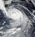
Tropical Storm Lionrock continued crawling toward the main island of Honshu, Japan, as NASA's Aqua and NASA-NOAA's Suomi NPP satellites passed overhead and gathered data on the storm. When NASA-NOAA's Suomi NPP satellite passed over Lionrock it was weakening and moving slowly toward Japan's big island. On Aug. 28 at 11:10 p.m. EDT (Aug. 29 at 0310 UTC), the Visible Infrared Imaging Radiometer Suite (VIIRS) instrument aboard NASA-NOAA's Suomi NPP satellite captured a visible image of the storm that showed the eye had become filled with clouds. The storm also appeared somewhat elongated.
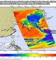
When NASA's Aqua satellite passed over the northwestern Pacific Ocean it gathered temperature data on Tropical Storm Lionrock. The Atmospheric Infrared Sounder or AIRS instrument aboard Aqua looked at Lionrock in infrared light on Aug. 29 at 12:11 a.m. EDT (0411 UTC). AIRS infrared data showed that Lionrock still had powerful thunderstorms with high cold cloud tops (as cold as minus 63 degrees Fahrenheit or minus 53 degrees Celsius). The strongest storms were located around the center of circulation and in a thick band extending southeast of the center.
On Aug. 29 at 11 a.m. EDT (1500 UTC), the center of Typhoon Lionrock was located near 32.7 degrees north latitude and 143.4 degrees west longitude. That's about 281 nautical miles southeast of Yokosuka, Japan. Maximum sustained winds were near 80.5 mph (70 knots/129.6 kph). Lionrock's typhoon-strength winds extend out 35 nautical miles from the center, while tropical storm-force winds have a much larger reach, out to 215 nautical miles from the center.
Lionrock is moving to the northeast at 13.8 mph (12 knots/22.2 kph) and generating waves up to 26 feet (7.9 meters) high.
Lionrock is weakening and is expected to make landfall in northern Honshu on Aug. 30 as it becomes extra-tropical. Once it crosses northern Japan it is forecast to make final landfall in extreme southeastern Russia on Wednesday, Aug. 31.
Source: NASA/Goddard Space Flight Center
Articles on the same topic
- NASA's Terra satellite spies tropical storm weakening Lionrock over HokkaidoTue, 30 Aug 2016, 18:14:36 UTC
- Typhoon Lionrock threatening JapanFri, 26 Aug 2016, 21:45:50 UTC
- Typhoon Lionrock's intensification seen by NASA's GPMFri, 26 Aug 2016, 21:45:37 UTC
Other sources
- Bodies found in nursing home as Typhoon Lionrock hits Japanfrom UPIWed, 31 Aug 2016, 11:31:13 UTC
- At least 9 dead as typhoon hits northern Japanfrom PhysorgWed, 31 Aug 2016, 7:01:33 UTC
- NASA's Terra satellite spies tropical storm weakening Lionrock over Hokkaidofrom PhysorgTue, 30 Aug 2016, 18:41:30 UTC
- Strong typhoon Lionrock heads for Japan's northeastfrom PhysorgTue, 30 Aug 2016, 6:51:26 UTC
- NASA sees Typhoon Lionrock approaching Japanfrom PhysorgMon, 29 Aug 2016, 20:01:28 UTC
- Typhoon Lionrock threatening Japanfrom PhysorgFri, 26 Aug 2016, 21:41:44 UTC
- Typhoon Lionrock's intensification seen by NASA's GPMfrom PhysorgThu, 25 Aug 2016, 17:01:34 UTC
- NASA sees Lionrock strengthen into a typhoonfrom PhysorgWed, 24 Aug 2016, 20:01:46 UTC

