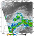
NASA's Terra satellite sees development of Depression 15W
Tropical Depression 15W has formed in the Northwestern Pacific Ocean and NASA's Terra satellite passed overhead and analyzed the storm in infrared light. At 9:35 a.m. EDT (1335 UTC) on Aug. 31, infrared data from the Moderate Resolution Imaging Spectroradiometer aboard NASA's Terra satellite showed cloud tops southeast and southwest of the center as cold as minus 70 degrees Fahrenheit (minus 56.6 degrees Celsius). Cold cloud tops indicate the area of strongest storms that stretch highest into the troposphere. The higher they are, the colder the air temperature.
AT 11 a.m. EDT, Tropical Depression 15W's maximum sustained winds were near 28.7 mph (25 knots/46.3 kph). Tropical Depression 15W was located approximately 289 nautical miles south-southwest of Kadena Air Force Base, Okinawa, Japan. It was centered near 22.3 degrees north latitude and 126.4 east longitude. Tropical Depression 15W was moving to the east-northeastward at 13.8 mph (12 knots/22.2 kph).
The Joint Typhoon Warning Center (JTWC) forecast calls for 15W to continue to the northeast and as it nears Minami Daito Jima Island, Japan on Sept. 2, it is expected to turn to the north-northwest.
Source: NASA/Goddard Space Flight Center
Articles on the same topic
- NASA's Terra satellite sees small burst in Tropical Depression MadelineFri, 2 Sep 2016, 18:06:19 UTC
- NASA satellite sees dissipation of Tropical Depression 8Thu, 1 Sep 2016, 15:24:37 UTC
- Intensifying Tropical Depression 9 checked by NASAWed, 31 Aug 2016, 19:44:47 UTC
- NASA gets 2 views of Tropical Depression 8 off the Carolina coastWed, 31 Aug 2016, 17:04:30 UTC
- Satellite sees large Tropical Depression 9 in the Gulf of MexicoTue, 30 Aug 2016, 17:15:13 UTC
- Satellites see Tropical Depression 8 off the North Carolina coastTue, 30 Aug 2016, 17:15:01 UTC
- NASA peers into Tropical Depression 9 in the Gulf of MexicoMon, 29 Aug 2016, 19:05:14 UTC
- Forming Atlantic Tropical Depression 8 seen by NASAMon, 29 Aug 2016, 19:05:02 UTC
Other sources
- NASA's Terra satellite sees small burst in Tropical Depression Madelinefrom PhysorgFri, 2 Sep 2016, 18:31:22 UTC
- NASA satellite sees dissipation of Tropical Depression 8from PhysorgThu, 1 Sep 2016, 15:01:32 UTC
- NASA's Terra satellite sees development of Depression 15Wfrom PhysorgWed, 31 Aug 2016, 22:31:28 UTC
- Intensifying Tropical Depression 9 checked by NASAfrom PhysorgWed, 31 Aug 2016, 20:02:10 UTC
- NASA gets 2 views of Tropical Depression 8 off the Carolina coastfrom PhysorgWed, 31 Aug 2016, 17:31:49 UTC
- Satellite sees large Tropical Depression 9 in the Gulf of Mexicofrom PhysorgTue, 30 Aug 2016, 18:41:30 UTC
- Satellites see Tropical Depression 8 off the North Carolina coastfrom PhysorgTue, 30 Aug 2016, 17:11:49 UTC
- Tropical storm warning issued for North Carolinafrom UPITue, 30 Aug 2016, 11:41:14 UTC
- NASA peers into Tropical Depression 9 in the Gulf of Mexicofrom PhysorgMon, 29 Aug 2016, 19:01:24 UTC
- Tropical depressions target Florida, North Carolinafrom UPIMon, 29 Aug 2016, 18:01:16 UTC
- Forming Atlantic Tropical Depression 8 seen by NASAfrom PhysorgMon, 29 Aug 2016, 15:31:33 UTC
- Tropical disturbance to bring soaking rain to Floridafrom UPISat, 27 Aug 2016, 19:31:14 UTC
- GPM examines Tropical Storm Lesterfrom PhysorgFri, 26 Aug 2016, 21:41:29 UTC
