NASA sees post-Tropical Storm Hermine south of Long Island, last advisory issued
Related images
(click to enlarge)
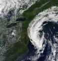
NOAA's National Hurricane Center (NHC) issued their final warning on Post-Tropical Cyclone Hermine yesterday, Sept. 6 at 2 p.m. EDT. NASA's Aqua satellite captured an image of the storm at that time and showed clouds stretching from New Jersey to Maine. At the time of the NHC's last advisory, Hermine's center was about 120 miles south of the eastern tip of Long Island, New York, near 39.4 degrees north latitude and 72.3 degrees west longitude. Maximum sustained winds have decreased to near 50 mph (85 kph) with higher gusts. Additional gradual weakening is likely during the next couple of days, and Hermine may weaken below tropical storm force by Thursday, Sept. 8.
On Sept. 6 at 2:20 p.m. EDT (18:20 UTC), the Moderate Resolution Imaging Spectroradiometer or MODIS instrument aboard NASA's Aqua satellite captured a visible image of Post-Tropical Storm Hermine. A thick band of strong thunderstorms covered the western side of the storm and extended from the Atlantic Ocean over Long Island. Bands of clouds stretched from New Jersey to Maine.
On Sept. 6, the NHC said Hermine was no longer a threat to land. Water levels remain elevated along the coast of Long Island, but they should subside during the next day or so as Hermine exits the area.
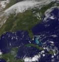
On Wednesday, Sept. 7 at 8:30 a.m. EDT (1230 UTC) NOAA's GOES-East satellite captured a visible image of the clouds associated with Hermine still spinning south of Long Island. Compared to the imagery from NASA's Aqua satellite the previous day, the clouds had thinned and there was only a line of thunderstorms around the western quadrant, while lower clouds surrounded the rest of the low pressure area. The image was created by NASA/NOAA's GOES Project at the NASA Goddard Space Flight Center in Greenbelt, Maryland.
The center of Post-Tropical Cyclone Hermine is expected to be over 150 miles east-southeast of Cape Cod, Massachusetts, by 2 a.m. EDT on Thursday, Sept. 8 as it continues to moving in a northeasterly direction into the open waters of the North Atlantic Ocean.
Large waves generated by Hermine will continue to affect the U.S. east coast from the Mid-Atlantic States through New England for another couple of days. These waves are likely to cause life-threatening surf and rip current conditions, and significant beach erosion.
Source: NASA/Goddard Space Flight Center
Articles on the same topic
- NASA takes parting look at HermineThu, 8 Sep 2016, 16:06:53 UTC
- NASA sees post-Tropical Cyclone Hermine linger over northeastern USThu, 8 Sep 2016, 16:06:22 UTC
- NASA animation shows landfall and progression of Hurricane HermineFri, 2 Sep 2016, 16:06:38 UTC
- NASA sees Hermine's twin towersFri, 2 Sep 2016, 15:07:34 UTC
- Hermine becomes a hurricane in the Gulf of MexicoThu, 1 Sep 2016, 21:23:09 UTC
- NASA's GPM sees increasingly organized Tropical Storm HermineThu, 1 Sep 2016, 16:35:23 UTC
Other sources
- NASA takes parting look at Herminefrom PhysorgThu, 8 Sep 2016, 16:01:44 UTC
- Scientists use undersea drones to help predict hurricanesfrom PhysorgThu, 8 Sep 2016, 7:31:28 UTC
- Scientists use undersea drones to help predict hurricanesfrom AP ScienceThu, 8 Sep 2016, 5:11:14 UTC
- NASA sees post-Tropical Storm Hermine south of Long Island, last advisory issuedfrom PhysorgWed, 7 Sep 2016, 16:31:20 UTC
- NASA sees post-Tropical Cyclone Hermine linger over northeastern USfrom PhysorgTue, 6 Sep 2016, 20:21:17 UTC
- Post-tropical cyclone Hermine moving toward northeast U.S.from UPITue, 6 Sep 2016, 2:11:21 UTC
- Hermine's storm surge threat shifts to New England coastfrom UPIMon, 5 Sep 2016, 14:31:13 UTC
- Forecasters: Hermine could reach hurricane strength again in Northeastfrom UPISun, 4 Sep 2016, 14:21:16 UTC
- Hermine kills two, ruins beach weekends in northward marchfrom PhysorgSun, 4 Sep 2016, 10:31:30 UTC
- Tropical Storm Hermine maintaining strength as it continues up East Coastfrom UPISat, 3 Sep 2016, 13:31:20 UTC
- Hurricane Season Is Heating Up. So Is the Planet. Coincidence?from NY Times ScienceSat, 3 Sep 2016, 0:21:13 UTC
- Hermine: Storm over Carolinas as Florida cleans up; 1 dead; 250K without powerfrom UPISat, 3 Sep 2016, 0:01:18 UTC
- NASA animation shows landfall and progression of Hurricane Herminefrom PhysorgFri, 2 Sep 2016, 16:01:19 UTC
- NASA sees Hermine's twin towersfrom PhysorgFri, 2 Sep 2016, 15:31:15 UTC
- Hurricane Hermine makes landfall on Florida's Gulf Coastfrom UPIFri, 2 Sep 2016, 10:01:18 UTC
- UW-Madison Scientists Help Fly Global Hawk Drone Into Hermine, Other Hurricanesfrom Newswise - ScinewsFri, 2 Sep 2016, 8:41:21 UTC
- Hurricane Hermine begins assault on Florida's Gulf Coastfrom UPIFri, 2 Sep 2016, 8:11:17 UTC
- Florida facing 'life-threatening' conditions as Hurricane Hermine approachesfrom UPIThu, 1 Sep 2016, 22:31:27 UTC
- Hurricane Hermine Threatens Florida in New Photo from Spacefrom Space.comThu, 1 Sep 2016, 22:11:16 UTC
- Hermine becomes a hurricane in the Gulf of Mexicofrom PhysorgThu, 1 Sep 2016, 21:31:18 UTC
- Hurricane Hermine Threatens Florida in New Photo from Spacefrom Live ScienceThu, 1 Sep 2016, 21:21:19 UTC
- NASA's GPM sees increasingly organized Tropical Storm Herminefrom PhysorgThu, 1 Sep 2016, 16:31:33 UTC
- Florida woman spots alligator swimming down flooded streetfrom UPIThu, 1 Sep 2016, 13:31:28 UTC
- Hurricane warnings for Florida panhandle as Tropical Storm Hermine takes aimfrom UPIThu, 1 Sep 2016, 11:01:48 UTC
- Tropical Storm Hermine picking up steam in Gulf; Florida declares emergenciesfrom UPIWed, 31 Aug 2016, 19:01:19 UTC
- Florida men facing felony charge over viral video of bare-handed alligator capturefrom UPIWed, 31 Aug 2016, 13:31:25 UTC
- Tropical Depression 9 could become hurricane before reaching Floridafrom UPIWed, 31 Aug 2016, 12:01:20 UTC

