Tropical Storm Claudette makes landfall in Florida, moving into Mississippi
By mid-day today, Monday, August 17, Claudette's center had moved into southwestern Alabama and weakened into a tropical depression. She'll turn toward the north-northwest later today and soak Alabama with up to 10 inches of rain in some isolated areas. At 2 a.m. EDT on Monday, August 17, Tropical Storm Claudette made landfall near Fort Walton Beach, Florida with maximum sustained winds near 50 mph. When it made landfall, tropical storm force winds extended 70 miles from the center, so towns from 70 miles to the east and west of Claudette's center received sustained winds over 37 mph.
The National Hurricane Center in Miami, Florida issued their last advisory on Claudette this morning at 7 a.m. EDT. Now, NOAA's Hydrometeorological Prediction Center (HPC) is issuing forecasts on Claudette as she moves through the interior U.S. At 10 a.m. EDT today, the HPC said that Claudette will track north-northwest through southwestern Alabama and northern Mississippi tonight.
The HPC expects "More precipitation to break out during the day across Alabama and the Florida panhandle mainly east of the circulation center." They "suspect that tonight there will be the potential for very heavy rainfall amounts near the center as it reaches into northern Mississippi, especially in overnight hours when convection often flares near the center of circulation. Still expect the potential for 3 to 6 inch totals with Claudette...and isolated totals up to 10 inches mainly within the stationary bands of rainfall across the Florida panhandle."
At 8 a.m. EDT the center of tropical depression Claudette was located near latitude 31.3 north and longitude 87.2 about, 15 Miles North-Northwest of Brewton, Alabama and about 85 miles southwest of Montgomery, Alabama. She was moving northwest near 12 mph. Claudette's sustained winds were down to 35 mph, and she'll continue to weaken today as she moves farther inland. The estimated minimum central pressure is 1011 millibars.
The National Weather Service in Tallahassee reported that the cities of Apalachicola and St. George areas saw a combined 4-6 inches of rain since Sunday morning. The highest wind gust in Apalachicola was reported at 50 mph.
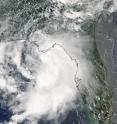
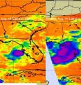
NASA's Aqua satellite captured Tropical Storm Claudette on Sunday, August 16 at 2:30 p.m. EDT (1:30 p.m. CDT) about 12 hours before her eye made landfall near Fort Walton Beach, Florida. The image was captured by the Moderate Imaging Spectroradiometer (MODIS) instrument. The Atmospheric Infrared Sounder (AIRS) instrument that measures cloud temperature using infrared light. The higher the clouds are, the colder they are. One interesting thing that AIRS showed forecasters was that the extent of the cloud cover almost doubled in 11 hours on Sunday, August 16 between 3:29 a.m. EDT and 2:29 p.m. EDT, when AIRS captured images of Claudette.
Now, residents of Alabama and Mississippi should expect heavy downpours and localized flooding from Claudette's rains. The system is expected to move toward the northwest and by tomorrow it is expected to have weakened to a depression over western Tennessee.
Source: NASA/Goddard Space Flight Center
Other sources
- Tropical Storm Claudette makes landfall in Florida, moving into Mississippifrom PhysorgMon, 17 Aug 2009, 22:49:41 UTC

