NASA satellite sees massive Tropical Storm Meari headed for Taiwan
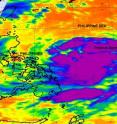
The AIRS instrument on NASA's Aqua satellite captured an infrared image of the western North Pacific's seventh tropical depression become massive Tropical Storm Meari overnight. Meari is so large that it takes up almost the entire Philippine Sea and it's on track toward southeastern Taiwan. Tropical Storm Meari's large area of cold thunderstorm cloud tops were captured on an infrared image from NASA's Atmospheric Infrared Sounder (AIRS) instrument on June 21 at 17:11 UTC (1:11 p.m. EDT). The strongest thunderstorms covered an area of hundreds of miles around what oddly appears to be two possible low-level circulation centers within the storm. There is one more dominant low-level circulation center where bands of thunderstorms are wrapping around it from the north. The secondary low-level center appears to be to the southeast where more bands of thunderstorms are wrapping around it from the southwest.
On June 22, Tropical Storm Meari had maximum sustained winds near 40 knots (46 mph/74 kmh)with higher gusts. It is about 315 nautical miles east-northeast of Manila, Philippines near 16.0 North and 125.9 East. It was moving northwestward near 15 knots (17 mph/28 kmh).
Meari is forecast to keep moving to the northwest for the next two days. It is expected to strengthen to typhoon status over that time, and before it reaches Taiwan. Forecasters at the Joint Typhoon Warning Center then expect Meari to cross into the Taiwan Strait and make cross over the eastern tip of China.
Source: NASA/Goddard Space Flight Center
Articles on the same topic
- NASA sees Tropical Depression Meari about to cross North VietnamMon, 27 Jun 2011, 21:02:49 UTC
- NASA sees Tropical Storm Haima poised for Vietnam landfallFri, 24 Jun 2011, 21:02:09 UTC
- NASA sees Tropical Storm Meari headed for North Korea landfallFri, 24 Jun 2011, 21:01:52 UTC
- NASA satellite gets 2 tropical cyclones in 1 shotThu, 23 Jun 2011, 19:38:50 UTC
- NASA sees heavy rainfall on southern side of Tropical Depression Haima as it nears Hong KongWed, 22 Jun 2011, 21:38:02 UTC
- Infrared NASA imagery reveals a weaker tropical cyclone in the South China SeaWed, 22 Jun 2011, 21:36:00 UTC
Other sources
- NASA sees Tropical Depression Meari about to cross North Vietnamfrom PhysorgMon, 27 Jun 2011, 21:00:41 UTC
- NASA sees Tropical Storm Haima poised for Vietnam landfallfrom PhysorgFri, 24 Jun 2011, 22:00:46 UTC
- NASA sees Tropical Storm Meari headed for North Korea landfallfrom PhysorgFri, 24 Jun 2011, 21:30:57 UTC
- Ыatellite gets two tropical cyclones in one shotfrom PhysorgThu, 23 Jun 2011, 20:00:55 UTC
- NASA satellite catches storm formingfrom UPIThu, 23 Jun 2011, 13:30:24 UTC
- NASA satellite catches storm formingfrom UPIThu, 23 Jun 2011, 3:30:20 UTC
- NASA sees heavy rainfall on southern side of Tropical Depression Haima as it nears Hong Kongfrom PhysorgWed, 22 Jun 2011, 21:30:46 UTC
- NASA satellite sees massive Tropical Storm Meari headed for Taiwanfrom PhysorgWed, 22 Jun 2011, 21:30:46 UTC
- Infrared NASA imagery reveals a weaker tropical cyclone in the South China Seafrom PhysorgTue, 21 Jun 2011, 20:31:43 UTC
