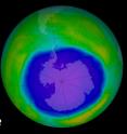
Annual Antarctic ozone hole larger and formed later in 2015
The 2015 Antarctic ozone hole area was larger and formed later than in recent years, said scientists from NASA and the National Oceanic and Atmospheric Administration (NOAA). On Oct. 2, 2015, the ozone hole expanded to its peak of 28.2 million square kilometers (10.9 million square miles), an area larger than the continent of North America. Throughout October, the hole remained large and set many area daily records. Unusually cold temperature and weak dynamics in the Antarctic stratosphere this year resulted in this larger ozone hole. In comparison, last year the ozone hole peaked at 24.1 million square kilometers (9.3 million square miles) on Sept. 11, 2014. Compared to the 1991-2014 period, the 2015 ozone hole average area was the fourth largest.
"While the current ozone hole is larger than in recent years, the area occupied by this year's hole is consistent with our understanding of ozone depletion chemistry and consistent with colder than average weather conditions in Earth's stratosphere, which help drive ozone depletion," said Paul A. Newman, chief scientist for Earth Sciences at NASA's Goddard Space Flight Center in Greenbelt, Maryland.
The ozone hole is a severe depletion of the ozone layer above Antarctica that was first detected in the 1980s. The Antarctic ozone hole forms and expands during the Southern Hemisphere spring (August and September) because of the high levels of chemically active forms of chlorine and bromine in the stratosphere. These chlorine- and bromine-containing molecules are largely derived from man-made chemicals that steadily increased in Earth's atmosphere up through the early 1990s.
"This year, our balloon-borne instruments measured nearly 100 percent ozone depletion in the layer above South Pole Station, Antarctica, that was 14 to 19 kilometers (9 to 12 miles) above Earth's surface," said Bryan Johnson, a researcher at NOAA's Earth System Research Laboratory in Boulder, Colorado. "During September we typically see a rapid ozone decline, ending with about 95 percent depletion in that layer by October 1. This year the depletion held on an extra two weeks resulting in nearly 100 percent depletion by October 15."
The ozone layer helps shield Earth from potentially harmful ultraviolet radiation that can cause skin cancer, cataracts, and suppress immune systems, as well as damage plants. The large size of this year's ozone hole will likely result in increases of harmful ultraviolet rays at Earth's surface, particularly in Antarctica and the Southern Hemisphere in the coming months.
Ozone depletion is primarily caused by man-made compounds that release chlorine and bromine gases in the stratosphere. Beginning in 1987, the internationally agreed-upon Montreal Protocol on Substances that Deplete the Ozone Layer has regulated these ozone-depleting compounds, such as chlorine-containing chlorofluorocarbons used in refrigerants and bromine-containing halon gases used as fire suppressants. Because of the Protocol, atmospheric levels of these ozone depleting compounds are slowly declining. The ozone hole is expected to recover back to 1980 levels in approximately 2070.
This year, scientists recorded the minimum thickness of the ozone layer at 101 Dobson units on October 4, 2015, as compared to 250-350 Dobson units during the 1960s, before the Antarctic ozone hole occurred. Dobson units are a measure of the overhead amount of atmospheric ozone.
The satellite ozone data come from the Dutch-Finnish Ozone Monitoring Instrument on NASA's Aura satellite, launched in 2004, and the Ozone Monitoring and Profiler Suite instrument on the NASA-NOAA Suomi National Polar-orbiting Partnership satellite, launched in 2011. NOAA scientists at the South Pole station monitor the ozone layer above that location by using a Dobson spectrophotometer and regular ozone-sonde balloon launches that record the thickness of the ozone layer and its vertical distribution. Chlorine amounts are estimated using NOAA and NASA ground measurements and observations from the Microwave Limb Sounder aboard NASA's Aura satellite. These satellites continue a data record dating back to the early 1970s.
Source: NASA/Goddard Space Flight Center
Other sources
- Annual Antarctic ozone hole larger and formed later in 2015from Science DailyFri, 30 Oct 2015, 2:41:47 UTC
- UN scientists insist ozone is recovering despite huge holefrom UPIThu, 29 Oct 2015, 20:50:25 UTC
- Ozone hole over Antarctica hits record sizefrom CBC: Technology & ScienceThu, 29 Oct 2015, 14:50:07 UTC
- UN weather body: Antarctic ozone hole expands due to coldfrom PhysorgThu, 29 Oct 2015, 14:20:30 UTC
- UN weather body: Antarctic ozone hole expands due to coldfrom AP ScienceThu, 29 Oct 2015, 13:20:10 UTC
