NASA sees category 5 southern Pacific Tropical cyclone hit Fiji
Related images
(click to enlarge)
NASA satellites provided data on Tropical Cyclone Winston before and after it made an historic landfall in eastern Fiji. The GPM, Suomi NPP and Aqua satellites provided forecasters with data that showed rainfall, strength and extent of the storm. Tropical Cyclone Winston made landfall on Feb. 20 in Vitu Levi, eastern Fiji as a Category 5 hurricane on the Saffir-Simpson Hurricane Wind Scale. Winston was the first cyclone of that strength to make landfall in Fiji in recorded history.
The Fiji Meteorological Service estimated wind gusts near Winston's center over 200 mph. On Feb. 20, 2016 at 0900 UTC (4 a.m. EST) after landfall, the Joint Typhoon Warning Center noted that Winston's maximum sustained winds were near 155 knots (178.4 mph/287.1 kph) gusting to 190 knots (218.6 mph/351.9 kph).
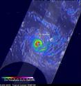
The Global Precipitation Measurement (GPM) core observatory satellite flew directly above tropical cyclone Winston on February 20, 2016 at 0941 UTC (4:41 a.m. EST). Tropical cyclone Winston had sustained winds estimated at 155 knots (178.4 mph/287.1 kph) at that time. A rainfall analysis derived from data collected by GPM's Microwave Imager (GMI) and Dual-frequency Precipitation Radar (DPR) instruments found that in addition to powerful winds Winston was dropping rain at a rate of over 169 mm (6.7 inches) per hour in the western side of the eye. Tropical cyclone Winston is the most powerful storm to hit Fiji.
On Saturday, Feb. 20, 2016 the Fiji government declared a State of Natural Disaster for Fiji for the next 30 days. That means that the government will send support to ensure the safety of members of the public, businesses, economy and national assets. The declaration means that police can now arrest people without warrant who fail to abide by the law.
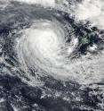
On Feb. 21, 2016 at 02:15 UTC (Feb. 20 at 9:15 p.m. EST) the MODIS (Moderate Resolution Imaging Spectroradiometer) instrument aboard NASA's Aqua satellite captured a visible image of Tropical Cyclone Winston in the South Pacific Ocean, west of Fiji. Even after passing over Fiji, Winston maintained an eye.
By 0900 UTC (4 a.m. EST) that day, seven hours after NASA's Aqua satellite captured an image of Tropical cyclone Winston, the storm still maintained maximum sustained winds near 125 knots (143.8 mph/231.5 kph) down from 130 knots (149.6 mph/240.8 kph) just 12 hours before. It was located about 253 nautical miles (291.3 miles/468.9 km) west of Suva, Fiji near 17.6 degrees south latitude and 174.0 degrees east longitude and was moving west-southwest.
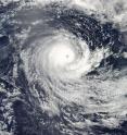
On Feb. 22, 2016 at 0200 UTC (Feb. 21 at 9 p.m. EST) the Visible Infrared Imaging Radiometer Suite (VIIRS) instrument aboard NASA-NOAA's Suomi NPP satellite captured this visible image of Tropical Cyclone Winston between Vanuatu to the west and Fiji to the east. Although still a hurricane, Winston's 20 nautical-mile-wide (23 miles/37 km) eye had become cloud-filled.
Joint Typhoon Warning Center said that the University of Wisconsin-Madison Cooperative Institute for Meteorological Satellite Studies microwave total precipitable water loop "indicates a band of dry air currently being entrained into the cyclone hindering further Intensification."
By 1500 GMT (10 a.m. EST) Winston's maximum sustained winds dropped to 90 knots (103.6 mph/166.7 kph) making it a Category 2 hurricane. Scatterometry satellite data showed that the hurricane-force winds extend 30 nautical miles (34 miles/55 km) from the center. It was located about 348 nautical miles (400.5 miles/644.5 km) west of Suva, Fiji near 18.2 degrees south latitude and 172.3 degrees east longitude. Winston was moving to the south slowly at 3 knots (3.4 mph/5.5 kph).
The JTWC noted that Winston will maintain current intensity for about a day because it is still over warm sea surface temperatures. Thereafter, Winston will begin weakening and eventually become sub-tropical south of New Caledonia.
The GPM satellite is co-managed by NASA and the Japan Aerospace Exploration Agency, and the Suomi NPP satellite is co-managed by NASA and NOAA.
Source: NASA/Goddard Space Flight Center
Articles on the same topic
- NASA's Terra satellite sees Tropical Cyclone Yalo coming to a quick endFri, 26 Feb 2016, 17:33:58 UTC
- NASA's Aqua satellite catches the birth of Tropical Cyclone YaloThu, 25 Feb 2016, 19:38:56 UTC
- NASA sees Winston winding down near Norfolk IslandThu, 25 Feb 2016, 19:38:38 UTC
- NASA sees strong vertical wind shear battering a weaker winstonWed, 24 Feb 2016, 18:13:03 UTC
- NASA sees pinhole eye seen in weakening Tropical Cyclone WinstonWed, 24 Feb 2016, 18:12:55 UTC
- NASA sees major Tropical Cyclone Winston approaching FijiFri, 19 Feb 2016, 22:53:32 UTC
- NASA infrared imagery shows wind shear affecting Tropical Cyclone UriahFri, 19 Feb 2016, 22:53:23 UTC
- NASA sees Tropical Cyclone Winston U-turn toward FijiFri, 19 Feb 2016, 22:53:14 UTC
- NASA catches Tropical Cyclone Uriah nearing peakFri, 19 Feb 2016, 22:52:53 UTC
- NASA sees Tropical Cyclone Winston intensifying near TongaFri, 19 Feb 2016, 22:52:43 UTC
Other sources
- NASA's Terra satellite sees Tropical Cyclone Yalo coming to a quick endfrom PhysorgFri, 26 Feb 2016, 18:01:39 UTC
- Aqua satellite catches the birth of Tropical Cyclone Yalofrom PhysorgThu, 25 Feb 2016, 19:30:38 UTC
- NASA sees Winston winding down near Norfolk Islandfrom PhysorgThu, 25 Feb 2016, 19:30:37 UTC
- NASA sees strong vertical wind shear battering a weaker winstonfrom PhysorgWed, 24 Feb 2016, 19:00:33 UTC
- NASA sees pinhole eye seen in weakening Tropical Cyclone Winstonfrom PhysorgTue, 23 Feb 2016, 18:30:39 UTC
- Monster Cyclone Winston Seen from Space (Photos)from Space.comTue, 23 Feb 2016, 14:50:27 UTC
- NASA sees category 5 southern Pacific Tropical cyclone hit Fijifrom PhysorgMon, 22 Feb 2016, 19:20:31 UTC
- Death toll in Fiji jumps to 20 as Cyclone Winston cleanup beginsfrom UPIMon, 22 Feb 2016, 14:30:36 UTC
- Death toll from Fiji cyclone hits 18 as aid sent to islandsfrom PhysorgMon, 22 Feb 2016, 9:30:32 UTC
- Major cyclone kills at least 10 in Fiji, destroys hundreds of homesfrom UPISun, 21 Feb 2016, 17:00:35 UTC
- Death toll from ferocious Fiji cyclone rises to 3from PhysorgSun, 21 Feb 2016, 9:30:38 UTC
- Powerful cyclone batters Fiji islands, maintains strengthfrom UPISat, 20 Feb 2016, 20:00:29 UTC
- Ferocious cyclone strikes Pacific island nation of Fijifrom PhysorgSat, 20 Feb 2016, 14:40:24 UTC
- Fiji hunkers down as formidable cyclone nears main islandsfrom PhysorgSat, 20 Feb 2016, 9:50:34 UTC
- Fiji hunkers down as formidable cyclone nears main islandsfrom AP ScienceSat, 20 Feb 2016, 4:00:28 UTC
- NASA sees major Tropical Cyclone Winston approaching Fijifrom PhysorgFri, 19 Feb 2016, 22:50:33 UTC
- NASA sees Tropical Cyclone Winston U-turn toward Fijifrom PhysorgThu, 18 Feb 2016, 21:01:03 UTC
- NASA catches Tropical Cyclone Uriah nearing peakfrom PhysorgWed, 17 Feb 2016, 19:42:51 UTC
- NASA sees Tropical Cyclone Winston intensifying near Tongafrom PhysorgWed, 17 Feb 2016, 19:42:49 UTC


