NASA catches Estelle becoming post-tropical
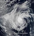
The Suomi NPP satellite passed over Tropical Storm Estelle as it was transitioning to a post-tropical storm in the Eastern Pacific Ocean. On July 22 at 0000 UTC (July 21 at 8 p.m. EDT) the Visible Infrared Imaging Radiometer Suite (VIIRS) instrument aboard the NASA-NOAA Suomi NPP satellite captured a visible light image of Tropical Storm Estelle. Estelle was still a tropical storm at the time of the image, but was devoid of strong convection (rising air that condenses into clouds and thunderstorms that make up a tropical cyclone). The VIIRS image showed clouds wrapping into the northwestern quadrant of the low level center of circulation. National Hurricane Center forecaster Aviles said "The circulation, however, is still vigorous."
VIIRS collects visible and infrared imagery and global observations of land, atmosphere, cryosphere and oceans.
By 11 a.m. EDT, Forecaster Brennan at the National Hurricane Center noted that Estelle had been lacking any deep convection for about 15 hours and was then designated as a post-tropical cyclone.
At 11 a.m. EDT (1500 UTC) on July 22 the National Hurricane Center issued their last public advisory on Estelle. At that time the center of Post-Tropical Cyclone Estelle was located near 21.8 north latitude and 133.5 west longitude. That's about 1,505 miles (2,425 km) west of the southern tip of Baja California.
The post-tropical cyclone is moving toward the west-northwest near 16 mph (26 kph) and this general motion is expected to continue for the next couple of days. Maximum sustained winds are near 40 mph (65 kph). Gradual weakening is forecast during the next 48 hours. Estelle should gradually spin down over the next couple of days as it moves over cool waters and dissipate in 48 to 72 hours.
Source: NASA/Goddard Space Flight Center
Articles on the same topic
- Satellite tracks the remnants of Tropical Storm GeorgetteWed, 27 Jul 2016, 18:38:20 UTC
- NASA sees compact Tropical Storm Frank weakeningWed, 27 Jul 2016, 18:04:02 UTC
- Eastern Pacific storms Georgette and Frank see-saw in strengthTue, 26 Jul 2016, 18:06:02 UTC
- NASA data show Hurricane Frank's fluctuation in strengthTue, 26 Jul 2016, 18:05:53 UTC
- NASA spies major Hurricane GeorgetteTue, 26 Jul 2016, 18:05:37 UTC
- NASA scans Tropical Storm Frank's windsTue, 26 Jul 2016, 18:05:28 UTC
- NASA spots Tropical Storm Darby as warnings posted in HawaiiSun, 24 Jul 2016, 19:01:50 UTC
- NASA's GPM observes newly formed Tropical Storm GeorgetteFri, 22 Jul 2016, 18:26:22 UTC
- NASA spots 'hot towers' in intensifying Tropical Storm FrankFri, 22 Jul 2016, 18:26:13 UTC
Other sources
- NASA sees compact Tropical Storm Frank weakeningfrom PhysorgWed, 27 Jul 2016, 20:41:19 UTC
- Satellite tracks the remnants of Tropical Storm Georgettefrom PhysorgWed, 27 Jul 2016, 20:11:16 UTC
- Eastern Pacific storms Georgette and Frank see-saw in strengthfrom PhysorgTue, 26 Jul 2016, 18:01:44 UTC
- NASA data show Hurricane Frank's fluctuation in strengthfrom PhysorgTue, 26 Jul 2016, 17:31:49 UTC
- NASA scans Tropical Storm Frank's windsfrom PhysorgMon, 25 Jul 2016, 20:31:20 UTC
- NASA spies major Hurricane Georgettefrom PhysorgMon, 25 Jul 2016, 20:01:10 UTC
- Tropical Storm Darby bearing down on Hawaiifrom UPISun, 24 Jul 2016, 1:01:11 UTC
- NASA catches Estelle becoming post-tropicalfrom PhysorgSat, 23 Jul 2016, 8:51:20 UTC
- NASA spots Tropical Storm Darby as warnings posted in Hawaiifrom PhysorgSat, 23 Jul 2016, 8:51:19 UTC
- NASA's GPM observes newly formed Tropical Storm Georgettefrom PhysorgFri, 22 Jul 2016, 18:21:41 UTC
- NASA Spots "Hot Towers" in Intensifying Tropical Storm Frankfrom PhysorgFri, 22 Jul 2016, 15:21:34 UTC
- GPM measured heavy rain in Tropical Storm Estellefrom PhysorgThu, 21 Jul 2016, 18:51:23 UTC
