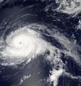
NASA eyes powerful Hurricane Gaston almost 600 miles from Bermuda
NASA's Aqua satellite passed over Hurricane Gaston as it was strengthening into a major hurricane, almost 600 miles away from Bermuda in the Atlantic Ocean. Aqua provided a visible look at the powerful hurricane. On Aug. 28 at 12:45 p.m. EDT (1645 UTC) the Moderate Resolution Imaging Spectroradiometer or MODIS instrument that flies aboard NASA's Aqua satellite captured a visible image of Hurricane Gaston. At the time, Gaston had maximum sustained winds near 105 mph and was a Category 2 hurricane on the Saffir-Simpson Hurricane Wind Scale. Gaston had developed a clear eye about 15 nautical miles wide that was surrounded by powerful thunderstorms. The storm later strengthened into a major hurricane.
At 5 a.m. EDT (0900 UTC) on Monday, Aug. 29 the center of Hurricane Gaston was located near 30.8 degrees north latitude and 55.2 degrees west longitude. Gaston is about 575 miles (925 km) east of Bermuda.
The National Hurricane Center (NHC) said that Gaston is currently drifting northward. A turn toward the northeast and a faster forward speed are expected later today, Aug. 29 or tonight, and an east-northeastward motion is expected on Tuesday. Maximum sustained winds have decreased to near 115 mph (185 kph) with higher gusts. Gaston is a category 3 hurricane on the Saffir-Simpson Hurricane Wind Scale. Additional slow weakening is forecast during the next 48 hours. The estimated minimum central pressure is 960 millibars.
NHC Forecaster Jack Beven stated in the 5 a.m. NHC Discussion, "Gaston remains a well-organized hurricane. However, the satellite appearance is slightly less impressive than 6 hours ago, with the eye becoming less distinct and the deep convection eroding in the northwestern quadrant."
By 5 a.m. EDT on Tuesday, Aug. 30, Gaston is expected to move over decreasing sea surface temperatures and into increasing vertical wind shear. Both of those factors should cause a gradual weakening.
Source: NASA/Goddard Space Flight Center
Articles on the same topic
- NASA observes a weaker Tropical Cyclone Gaston, warnings up in AzoresFri, 2 Sep 2016, 16:06:28 UTC
- NASA satellite sees Hurricane Gaston headed toward the AzoresThu, 1 Sep 2016, 14:56:19 UTC
- NASA observes large eye of Hurricane GastonThu, 1 Sep 2016, 11:04:28 UTC
- NASA spots Central Pacific's Madeline strengthening into a hurricaneMon, 29 Aug 2016, 18:04:37 UTC
- NASA sees Lester strengthening into fourth major Eastern Pacific hurricaneMon, 29 Aug 2016, 18:04:26 UTC
- Two NASA satellites take a bead on Gaston's movementsFri, 26 Aug 2016, 18:44:21 UTC
- NASA's GPM examines Tropical Storm LesterFri, 26 Aug 2016, 16:16:47 UTC
- NASA sees heavy rain in Gaston as it fights wind shearFri, 26 Aug 2016, 6:53:56 UTC
Other sources
- NASA observes a weaker Tropical Cyclone Gaston, warnings up in Azoresfrom PhysorgFri, 2 Sep 2016, 16:31:19 UTC
- NASA satellite sees Hurricane Gaston headed toward the Azoresfrom PhysorgThu, 1 Sep 2016, 15:01:30 UTC
- NASA observes large eye of Hurricane Gastonfrom PhysorgWed, 31 Aug 2016, 16:31:36 UTC
- NASA eyes powerful Hurricane Gaston almost 600 miles from Bermudafrom PhysorgMon, 29 Aug 2016, 16:01:23 UTC
- NASA sees Lester strengthening into fourth major Eastern Pacific hurricanefrom PhysorgMon, 29 Aug 2016, 16:01:22 UTC
- Tropical depression forms off Carolinas coast as disturbance gains strengthfrom UPISun, 28 Aug 2016, 17:21:13 UTC
- Two NASA satellites take a bead on Gaston's movementsfrom PhysorgFri, 26 Aug 2016, 21:41:45 UTC
- NASA sees heavy rain in Gaston as it fights wind shearfrom PhysorgFri, 26 Aug 2016, 6:51:15 UTC
- Tropical wave '99L' remains disorganized while Hurricane Gaston expected to weakenfrom UPIThu, 25 Aug 2016, 14:31:22 UTC
- Hurricane Gaston expected to weaken; next storm could organize Thursdayfrom UPIThu, 25 Aug 2016, 13:01:26 UTC
- Gaston expected to become hurricane Wednesday; disturbance strengthensfrom UPIWed, 24 Aug 2016, 15:31:12 UTC
- Tropical Storm Gaston to turn into hurricane by Wednesdayfrom UPITue, 23 Aug 2016, 11:31:20 UTC
