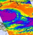
Typhoon Morakot's cloud top extent doubled in size in 1 day
Satellite imagery over the last two days has shown Typhoon Morakot to be a monster, and over the last two days, NASA satellites have confirmed the typhoon doubled its size! "Our satellite scan swath width is 1700 kilometers (1,056 miles) and Morakot looks to be almost that much in diameter in the infrared imagery on August 5," said Ed Olsen, of NASA's Jet Propulsion Laboratory in Pasadena, Calif. Olsen provides images for the Atmospheric Infrared Sounder (AIRS) instrument on the Aqua satellite. "On August Morakot was only about 1/2 the width of our swath width, near 850 kilometers (528 miles) in diameter!"
To put it into perspective, 1,056 miles is longer than the distance from Philadelphia, Pennsylvania to Orlando, Florida. Olsen said that it's important to know that satellite image represents the lateral extent of the cold cloud tops and that the winds definitely do not extend over an area 1,000 miles in diameter.
AIRS captured an infrared image of Typhoon Morakot tracking through the East China Sea on August 6 at 12:35 a.m. EDT (0435 UTC). At 11 a.m. EDT on Aug. 6, Morakot was closing in on Taiwan and was located 240 miles east-southeast of Taipei, Taiwan, near 23.2 north and 125.0 east. Morakot the monster has maximum sustained winds near 92 mph (80 knots) and was moving west near 14 mph.
AIRS provides visible, infrared and microwave images of tropical storms. AIRS also measures cloud top temperature and pressure and the profile of water vapor as functions of height. Infrared imagery shows the temperature of the cloud tops which gives a hint about the power of the thunderstorms in a tropical cyclone. The colder the clouds are, the higher they are, and the more powerful the thunderstorms are that make up the cyclone.
Typhoon Morakot is forecast to strengthen more before it crosses northern Taiwan later today and makes a final landfall in China by the weekend.
Source: NASA/Goddard Space Flight Center
Articles on the same topic
- NASA satellite image shows deadly Typhoon Morakot slamming TaiwanFri, 7 Aug 2009, 17:11:38 UTC
Other sources
- NASA satellite image shows deadly Typhoon Morakot slamming Taiwanfrom PhysorgFri, 7 Aug 2009, 18:56:42 UTC
- NASA satellite image shows deadly Typhoon Morakot slamming Taiwanfrom Science BlogFri, 7 Aug 2009, 18:35:23 UTC
- NASA satellite image shows deadly Typhoon Morakot slamming Taiwanfrom Science BlogFri, 7 Aug 2009, 17:49:15 UTC
- Typhoon Morakot's Cloud Top Extent Doubled In Size In 1 Dayfrom Science DailyFri, 7 Aug 2009, 2:15:18 UTC
- Typhoon Morakot's cloud top extent doubled in size in one dayfrom PhysorgThu, 6 Aug 2009, 19:35:40 UTC
- Typhoon Morakot's cloud top extent doubled in size in 1 dayfrom Science BlogThu, 6 Aug 2009, 17:42:43 UTC
