Tropical Storm Rick's center expected to pass south of the Baja
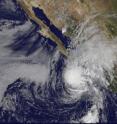
Residents in southern Baja California, Mexico still haven't recovered from last month's Hurricane Jimena, and Tropical Storm Rick is now bringing rains to southern tip of the Baja. The National Hurricane Center revised its forecast track at 11 a.m. EDT and it keeps Rick's center over open waters with a landfall in western mainland Mexico. The GOES-11 satellite (Geostationary Operational Environmental Satellite) captured a visible image of Tropical Storm Rick on October 20 at 7:30 a.m. PDT (11:30 a.m. EDT), and it showed that the northern edge of Rick's clouds were already over the southern Baja.
On October 20 at 10:50 a.m. EDT (7:50 PDT), the airport at San Jose del Cabo, Baja California, Mexico was reporting light rain, and light winds from the west at 2 mph.
A tropical storm warning in effect for southern Baja California, from Agua Blanca to Buena Vista including Cabo San Lucas. Tropical storm conditions are expected within 24 hours. A tropical storm watch is in effect for mainland Mexico from Roblito to Altata, and for southern Baja California from Buena Vista to La Paz. Tropical storm conditions are likely within 36 hours.
At 8 a.m. PDT (11 a.m. EDT) today, October 20, Tropical Storm Rick had maximum sustained winds near 65 mph. His center was 90 miles north of Socorro Island, and 200 miles south-southwest of Cabo San Lucas, Mexico. Cabo San Lucas is the southern-most city on the Baja. Rick was located near latitude 20.1 north and longitude 110.8 west, and moving northeast near 7 mph. Minimum central pressure is estimated near 991 millibars.
Tropical storm force winds extend outward up to 160 miles (260 km) from the center, so that's why Cabo San Lucas had very light winds at 10:50 a.m. EDT. Rick's center was too far away.
The National Hurricane Center is now forecasting Rick's center to pass near or to the south of the southern tip of Baja California tonight or early Wednesday, and approach the western coast of mainland Mexico on Wednesday.
The National Hurricane Center (NHC) noted that heavy rainfall can be expected in extreme southern Baja California as Rick nears and passes, and in northwestern Mexico when Rick makes landfall. The latest NHC discussion reads, "Total rainfall accumulations of 4 to 6 inches...with isolated amounts of 10 inches...are possible over extreme southern Baja California as well as the states of sinaloa and Durango in west-central Mexico during the next few days. These rains could produce life-threatening flash floods and mud slides."
Large ocean swells are already battering portions of the southern Baja coast and west-central coast of mainland Mexico and will continue over the next couple of days. In fact,
Carnival Cruise Lines announced that they were diverting two cruise ships until Tropical Storm Rick has passed. In the state of Nayarit on the mainland, the port of San Blas was closed.
GOES-11 is operated by the National Oceanic and Atmospheric Administration, and images are created by NASA's GOES Project, located at NASA's Goddard Space Flight Center, Greenbelt, Md.
Rick is expected to make landfall in mainland Mexico during the day time on Wednesday, October 21.
Source: NASA/Goddard Space Flight Center
Articles on the same topic
- NASA Satellites and Baja California on watch as Hurricane Rick approachesMon, 19 Oct 2009, 20:36:34 UTC
Other sources
- Tropical Storm Rick's center expected to pass south of the Bajafrom Science BlogTue, 20 Oct 2009, 21:14:16 UTC
- Tropical Storm Rick's center expected to pass south of the Bajafrom PhysorgTue, 20 Oct 2009, 20:56:13 UTC
- NASA Satellites and Baja California on watch as Hurricane Rick approachesfrom PhysorgMon, 19 Oct 2009, 20:35:28 UTC
