Mirinae floods Philippines, makes landfall in Vietnam with strong thunderstorms
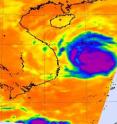
Mirinae (Santi) caused 12 hours of flooding rains in the Philippines when it crossed the northern Luzon region over the weekend. On October 31 at 5 a.m. Local (Asia/Manila) Time (October 30 at 2100 UTC) Typhoon Mirinae weakened dramatically after it moved inland over central Luzon, the Philippines. By October 31 at 5 p.m. Local time, Mirinae had already reemerged into the South China Sea as a tropical storm and was headed for Vietnam, but it left behind floods, destruction and death. Mirinae made landfall in Vietnam early this morning, Eastern Time. NASA's Aqua satellite captured an image of Mirinae as it tracked through the South China Sea yesterday, November 1 and had maximum sustained winds near 57 mph. The storm still maintained good formation, and Aqua's Atmospheric Infrared Sounder (AIRS) instrument still showed some high thunderstorms implying moderate to heavy rainfall, within. The infrared imagery also showed an eye in the storm, where the clouds were lower and warmer. The surrounding clouds had temperatures colder than -63F than those in the "eye."
By November 2 at 10 a.m. EDT or 7 p.m. local (Asia/Ho_Chi_Minh) time in Vietnam, Tropical Storm Mirinae had already crossed the South China Seas and made landfall in Vietnam. It made landfall around 1 a.m. EDT this morning, November 2. By 10 a.m. EDT today, it was located 155 miles northeast of Ho Chi Minh, Vietnam, near 12.7 North and 108.5 East. Mirinae had maximum sustained winds near 52 mph, and was moving west near 14 mph.
Mirinae is now dissipating over Vietnam and western Cambodia. The storm's remnants could move into the Gulf of Thailand, but Mirinae isn't expected to regenerate.
When Mirinae, or Santi as it was called in the Philippines, tracked over northern Luzon, it dropped copious amounts of rainfall causing serious flooding, power outages and landslides taking at least 10 lives. More than 10,000 people in 54 villages were reported affected.
When Mirinae left Luzon and entered the South China Sea late on October 31, its maximum sustained winds were down to 63 mph (55 knots) and it was a tropical storm. Early this morning it made its final landfall in Vietnam.
Today brings a day of clean up in Luzon, but an awareness of yet another tropical threat. 320 miles northeast of Manila in the Philippine Sea, another tropical depression has formed and it may track over the northern Philippines in the next several days.
Source: NASA/Goddard Space Flight Center
Articles on the same topic
- NASA's TRMM satellite provides a rainfall map of Mirinae's flooding rainsTue, 3 Nov 2009, 21:25:12 UTC
- Typhoon Mirinae already raining on the PhilippinesFri, 30 Oct 2009, 20:47:09 UTC
- Typhoon Mirinae is already scaring Philippine residents before HalloweenThu, 29 Oct 2009, 20:38:42 UTC
- Mirinae intensifying while moving away from the northern MarianasWed, 28 Oct 2009, 19:51:03 UTC
- Microwave satellite imagery shows an eye developing in MirinaeTue, 27 Oct 2009, 19:52:52 UTC
Other sources
- NASA's TRMM satellite provides a rainfall map of Mirinae's flooding rainsfrom Science BlogWed, 4 Nov 2009, 12:28:26 UTC
- NASA's TRMM satellite provides a rainfall map of Mirinae's flooding rainsfrom Science BlogWed, 4 Nov 2009, 2:21:23 UTC
- Mirinae floods Philippines, makes landfall in Vietnam with strong thunderstormsfrom PhysorgMon, 2 Nov 2009, 21:07:24 UTC
- Typhoon Mirinae already raining on the Philippinesfrom Science BlogFri, 30 Oct 2009, 22:14:36 UTC
- Typhoon Mirinae already raining on the Philippinesfrom PhysorgFri, 30 Oct 2009, 21:49:29 UTC
- Typhoon Mirinae is already scaring Philippine residents before Halloweenfrom PhysorgThu, 29 Oct 2009, 21:35:05 UTC
- Typhoon Mirinae is already scaring Philippine residents before Halloweenfrom Science BlogThu, 29 Oct 2009, 21:14:30 UTC
- Mirinae intensifying while moving away from the northern Marianasfrom Science BlogThu, 29 Oct 2009, 9:35:16 UTC
- Mirinae intensifying while moving away from the northern Marianasfrom Science BlogThu, 29 Oct 2009, 1:56:12 UTC
- Mirinae intensifying while moving away from the northern Marianasfrom PhysorgWed, 28 Oct 2009, 20:21:20 UTC
- Microwave satellite imagery shows an eye developing in Mirinaefrom PhysorgTue, 27 Oct 2009, 19:49:25 UTC
