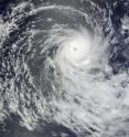
NASA's Terra satellite spots Tropical Cyclone Anja, the first of the southern season
NASA's Terra satellite captured a stunning image of Anja, the first tropical cyclone of the southern Hemisphere cyclone season. When Anja formed on Saturday, November 14, in the Southern Indian Ocean, about 330 miles south-southwest of Diego Garcia it was designated Tropical Cyclone 01S ("S" for south). By Sunday, November 15, 01S had strengthened into a tropical storm and was named Anja. On Monday, November 16, Anja had grown into a Category Three cyclone on the Saffir-Simpson Scale, packing maximum sustained winds near 105 knots (120 mph). NASA's Terra satellite flew over Anja, and the Moderate Imaging Spectroradiometer (MODIS) instrument captured an image of the storm that showed a cloud-filled eye in the center of circulation. Anja was located 795 miles east-northeast of Port Louis, Mauritius, near 13.4 North and 69.3 East. Anja was moving southwest at 4 mph.
Anja was a medium-sized cyclone with tropical storm-force winds extending out to 100 miles from its center, and cyclone (or hurricane)-force winds out to 45 miles from its center. Anja was generating waves as high as 24 feet, and is not threatening any landmasses.
Forecasters at the U.S. Navy's Joint Typhoon Warning Center expect that Anja will move south over the next couple of days and weaken under wind shear.
Source: NASA/Goddard Space Flight Center
Articles on the same topic
- NASA's QuikScat and Aqua providing important data on Tropical Storm AnjaWed, 18 Nov 2009, 15:36:08 UTC
- Cyclone Anja hits wind shear, weakens drasticallyTue, 17 Nov 2009, 20:25:02 UTC
Other sources
- QuikScat and Aqua providing important data on Tropical Storm Anjafrom PhysorgWed, 18 Nov 2009, 16:35:43 UTC
- Cyclone Anja hits wind shear, weakens drasticallyfrom Science BlogWed, 18 Nov 2009, 3:42:40 UTC
- Cyclone Anja hits wind shear, weakens drasticallyfrom Science BlogWed, 18 Nov 2009, 2:14:26 UTC
- Cyclone Anja hits wind shear, weakens drasticallyfrom PhysorgTue, 17 Nov 2009, 20:49:13 UTC
- Terra satellite spots Tropical Cyclone Anja, the first of the southern seasonfrom PhysorgMon, 16 Nov 2009, 21:14:08 UTC
