Tropical Cyclone Mick forms quickly, hits Fiji in the southwestern Pacific
Tropical Cyclone Mick formed over the weekend in the southwestern Pacific Ocean and made a quick landfall over Fiji's main island of Viti Levu earlier today, December 14. Mick made landfall as a Category 2 Cyclone and brought heavy rains and gusty winds to the island. Viti Levu authorities reported torrential rainfall and gale force winds that caused power outages. Fortunately, there were no casualties. The Fiji Times reported tourists were safe on both the Yasawa and Mamanuca groups of islands. However, the city of Lautoka is dealing with power outages.
Cyclone Mick has already passed through the Fiji Islands and the Tropical Cyclone Warning remains in effect for the southeastern half of Viti Levu, Vatulele, Beqa, Kadavu and nearby smaller islands. The rest of Fiji is under a gale warning.
On December 14, at 1500 UTC (10 a.m. ET) Tropical Cyclone Mick had weakened to a tropical storm after making landfall as a Category One Cyclone on the Saffir-Simpson Scale with maximum sustained winds near 74 mph (65 knots). Mick now has maximum sustained winds near 63 mph (55 knots). Tropical storm-force winds extend 55 miles from Mick's center.
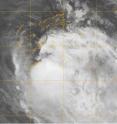
The Moderate Resolution Imaging Spectroradiometer instrument on NASA's Aqua satellite captured an infrared image of Cyclone Mick today at 1332 UTC (8:32 a.m. ET) and noticed that the storm did not have an eye, and the storm was becoming less symmetrical- two factors that indicate weakening.
Mick was located 80 miles southeast of Nadi, Fiji near 17.5 degrees South latitude and 177.7 degrees East longitude. Over the last 12 hours, the storm traveled 100 miles. It slowed down more than 10 mph, and is now moving southeast near 7 mph.
Mick is now dealing with wind shear, which is weakening the storm. Mick will also start transitioning into an extra-tropical storm within 12 hours.
Source: NASA/Goddard Space Flight Center
Articles on the same topic
- Tropical Cyclone 05B forms southeast of Chennai, IndiaFri, 11 Dec 2009, 23:26:00 UTC
Other sources
- Tropical Cyclone Mick forms quickly, hits Fiji in the southwestern Pacificfrom Science BlogTue, 15 Dec 2009, 6:56:39 UTC
- Tropical Cyclone Mick forms quickly, hits Fiji in the southwestern Pacificfrom PhysorgTue, 15 Dec 2009, 0:07:21 UTC
- Tropical Cyclone 05B forms southeast of Chennai, Indiafrom Science BlogFri, 11 Dec 2009, 23:28:11 UTC
- Tropical Cyclone 05B forms southeast of Chennai, Indiafrom PhysorgFri, 11 Dec 2009, 23:21:27 UTC
