Super cyclone Edzani staying safely at sea spawning super swells
It's a good thing that Cyclone Edzani is far away from land and will stay that way this weekend, because it's a powerful cyclone. In fact it's a Category 4 cyclone on the Saffir-Simpson scale generating waves almost as tall as a three-story building! On January 8 at 10 a.m. ET (1500 UTC), Cyclone Edzani had maximum sustained winds near 155 mph! That's 135 knots or 250 kilometers per hour, and it has higher gusts. Edzani's powerful hurricane-force winds extend out 40 miles from its center, while tropical storm-force winds extend up to 130 miles from the center.
Edzani was centered about 590 nautical miles south-southeast of Diego Garcia near 16.2 degrees South latitude and 76.7 degrees East longitude, safely away from any land areas. Edzani was moving southwestward near 9 mph (8 knots/14 km/hr).
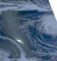
The Atmospheric Infrared Sounder (AIRS) instrument on NASA's Aqua satellite captured a visible image of the western half of Edzani's clouds early today, January 8 at 0905 UTC (4:05 a.m. ET) as it flew overhead. Edzani's eye was visible in the image, and forecasters at the Joint Typhoon Warning Center confirmed that the eye was 15 nautical miles in diameter using infrared and microwave imagery, such as that also provided by AIRS. It's a powerful storm that is generating waves up to 32 feet high, that's almost three stories high in a building!
If a Category four cyclone (or hurricane) made landfall it would do severe damage. Fortunately, Edzani is going to by-pass land. For those who are curious, however, the Saffir-Simpson Scale says that a Category 4 storm would have: "Sustained winds 131-155 mph (114-135 knots or 210-249 km/hr). Extremely dangerous winds causing devastating damage are expected. Some wall failures with some complete roof structure failures on houses will occur. All signs are blown down. Complete destruction of mobile homes (primarily pre-1994 construction). Extensive damage to doors and windows is likely. Numerous windows in high rise buildings will be dislodged and become airborne. Windborne debris will cause extensive damage and persons struck by the wind-blown debris will be injured or killed. Most trees will be snapped or uprooted. Fallen trees could cut off residential areas for days to weeks. Electricity will be unavailable for weeks after the hurricane passes."
Over the weekend, Edzani will continue moving in a southwesterly direction. By early next week, Edzani will be far southeast of Port Louis and Reunion Island as it continues on its track. By then, Edzani will have entered into cooler waters and will be a weaker storm.
Source: NASA/Goddard Space Flight Center
Articles on the same topic
- NASA satellite sees Tropical Storm Edzani becoming extra-tropicalWed, 13 Jan 2010, 20:25:43 UTC
- NASA satellite sees rainfall in ebbing EdzaniTue, 12 Jan 2010, 16:08:17 UTC
- Still safely at sea, Edzani now a tropical stormMon, 11 Jan 2010, 18:57:06 UTC
Other sources
- NASA satellite sees Tropical Storm Edzani becoming extra-tropicalfrom PhysorgWed, 13 Jan 2010, 20:56:27 UTC
- NASA satellite sees rainfall in ebbing Edzanifrom PhysorgTue, 12 Jan 2010, 19:21:25 UTC
- NASA satellite sees rainfall in ebbing Edzanifrom Science BlogTue, 12 Jan 2010, 17:14:36 UTC
- Still safely at sea, Edzani now a tropical stormfrom Science BlogMon, 11 Jan 2010, 19:42:15 UTC
- Still safely at sea, Edzani now a tropical stormfrom PhysorgMon, 11 Jan 2010, 19:14:16 UTC
- Super cyclone Edzani staying safely at sea spawning super swellsfrom Science BlogFri, 8 Jan 2010, 23:28:10 UTC
- Super cyclone Edzani staying safely at sea spawning super swellsfrom PhysorgFri, 8 Jan 2010, 21:35:09 UTC
- Super cyclone Edzani staying safely at sea spawning super swellsfrom Science BlogFri, 8 Jan 2010, 21:14:24 UTC
