Olga restrengthens into a tropical storm
Residents of the northern coastal areas of Australia's Northern Territory and NASA's Aqua satellite have seen new life "blown into" a low pressure system that is once again Tropical Storm Olga. At 16:00 UTC on Wednesday, January 27 (11 a.m. U.S. Eastern Time) or 1 a.m. Thursday January 28, 2010 in Australia/Darwin, Tropical Storm Olga had maximum sustained winds near 39 mph (35 knots). Its center was still over land near 16.0 degrees South and 136.4 degrees East. That's about 9 miles (15 kilometers) northeast of Borroloola and 136 miles (220 kilometers) south of Groote Eylandt. Olga was moving northwest near 4 mph (7 km/hr) and had a minimum central pressure near 994 millibars.
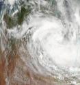
The Moderate Imaging Resolution Spectroradiometer, or MODIS instrument on NASA's Aqua satellite captured a visible image of Tropical Storm Olga on Jan. 27 at 4:40 UTC (1 p.m. Australia/Darwin Time) as it was tracking from Queensland to the Northern Territory.
Tropical Storm Olga is forecast to move slowly off-shore later today, where it may reach hurricane strength.
A Cyclone Warning remains in effect for the coastal and island communities from Cape Shield in the Northern Territory to Burketown in Queensland, including Groote Eylandt and Mornington Island. A Cyclone Watch is still in effect for coastal and island communities from Burketown to Kowanyama in Queensland.
Recent animated multispectral satellite and composite radar imagery from Mornington Island in Queensland suggest that the low-level circulation center is still over land, and hasn't exited into the Gulf of Carpentaria.
Borroloola, the nearest reporting station to Olga's center, reported a sea level pressure at 994.1 millibars, which generally supports at least a 39 mph (35 knot) circulation. That's tropical storm strength.
Gusty winds between the Northern Territory and Queensland border are expected today, along with heavy rains, possible flooding of small streams and low-lying areas and abnormally high tides between Bing Bong in the Northern Territory and Burketown in Queensland today.
Olga is forecast to turn north and enter the Gulf, where it will strengthen and then move back toward the east. Low wind shear and warm sea surface temperatures, ranging from 82-86 degrees Fahrenheit (28 -30 Celsius) will allow for intensification in the next two days before Olga makes another landfall near the Queensland border on Friday.
Source: NASA/Goddard Space Flight Center
Articles on the same topic
- Olga now raining on third of 5 Australia territoriesMon, 1 Feb 2010, 21:08:34 UTC
- Tropical Storm Olga: Three times a ladyFri, 29 Jan 2010, 20:26:44 UTC
- Olga's track is a puzzle forecasters are putting togetherThu, 28 Jan 2010, 20:47:24 UTC
Other sources
- Olga now raining on third of 5 Australia territoriesfrom PhysorgMon, 1 Feb 2010, 23:14:09 UTC
- Olga now raining on third of 5 Australia territoriesfrom Science BlogMon, 1 Feb 2010, 21:21:27 UTC
- Tropical Storm Olga: Three times a ladyfrom Science BlogSat, 30 Jan 2010, 0:21:21 UTC
- Tropical Storm Olga: Three times a ladyfrom Science BlogFri, 29 Jan 2010, 20:56:11 UTC
- Tropical Storm Olga: Three times a ladyfrom PhysorgFri, 29 Jan 2010, 20:42:36 UTC
- Olga's track is a puzzle forecasters are putting togetherfrom PhysorgThu, 28 Jan 2010, 21:28:27 UTC
- Olga restrengthens into a tropical stormfrom PhysorgWed, 27 Jan 2010, 21:21:31 UTC
- Olga restrengthens into a tropical stormfrom Science BlogWed, 27 Jan 2010, 20:28:25 UTC
