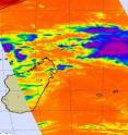
NASA sees sixteenth South Pacific cyclone form
During the early morning hours on Tuesday, February 16, the sixteenth tropical cyclone formed in the South Pacific Ocean and NASA captured an infrared image of its cold clouds, watching as it strengthens. Tropical Cyclone 16S has already powered up into a tropical storm, and is headed in the direction of Port Louis and Reunion Island in the next couple of days.
At 10 a.m. ET (1500 UTC) on February 16, Tropical Storm 16S (TS 16S)) had maximum sustained winds near 52 mph (45 knots). It was about 575 nautical miles north-northeast of La Reunion Island, near 13.1 South and 60.6 East, so it has a good way to go before affecting the island. It was moving south at 9 mph (8 knots).
NASA's Aqua satellite flew over Tropical Storm 16S on February 15 at 5:05 a.m. ET (1005 UTC) when it was still coming together and noticed that some strong convection was flaring up in its center. Convection is rapidly rising air that creates the thunderstorms that power tropical cyclones. Some of the thunderstorms in TS16S's center at that time were already very strong, and very high, with cloud top temperatures colder than -63 degrees Fahrenheit!
This morning's multispectral satellite imagery showed even deeper convection near the low level circulation center in addition to rain bands that are starting to wrap into TS 16's center.
TS 16S is expected to intensify over the next two days on its southern journey because of low wind shear and warm waters in its path.
Residents of Port Louis, Reunion Island and Mauritius should watch local forecasts and monitor this storm.
Source: NASA/Goddard Space Flight Center
Other sources
- NASA sees sixteenth South Pacific cyclone formfrom Science BlogWed, 17 Feb 2010, 0:21:24 UTC
- NASA sees sixteenth South Pacific cyclone formfrom PhysorgTue, 16 Feb 2010, 22:49:11 UTC
