Cyclone 24S now all grown up and renamed Tropical Storm Sean
Weather systems that become tropical cyclones go through a couple of names before they mature, just like people with nicknames. Such is the case with Cyclone 24S in the Southern Indian Ocean that was just renamed Tropical Storm Sean. Weather systems that become tropical cyclones go through a couple of names before they mature, just like people with nicknames. Such is the case with Cyclone 24S in the Southern Indian Ocean that was just renamed Tropical Storm Sean.
When a weather system develops it is given a weather system number to keep track of it. For example, Sean was "born" as System 91S on April 21 about 630 nautical miles north-northwest of Port Hedland, Australia. On April 22, System 91S strengthened and developed tropical cyclone characteristics but wasn't quite a tropical storm, so it was renamed as the twenty-fourth tropical cyclone in the Southern Hemisphere, "Tropical Cyclone 24S." After strengthening further and reaching tropical storm status, it received a human name and became "Tropical Storm Sean." So, it went through two numbered nicknames to get its "grown-up name."
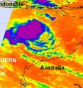
The Atmospheric Infrared Sounder (AIRS), instrument that flies aboard NASA's Aqua satellite from April 22 at 17:29 UTC (1:29 p.m. EDT) showed some strong, high, cold thunderstorms around Sean's center.
Infrared imagery is false-colored and higher cloud tops of stronger storms are depicted in purple. Sean showed a circular area of high, strong thunderstorms around his center of circulation. Those highest thunderstorms are as cold as or colder than 220 Kelvin or minus 63 degrees Fahrenheit (F).
On Friday, April 23 at 1500 UTC (11 a.m. EDT) Tropical Storm Sean had maximum sustained winds near 45 knots (52 mph). It was about 475 nautical miles north of Learmonth, Australia, near 14.4 South and 113.3 East. It was moving southeast at 4 knots (5 mph).
Animated infrared satellite imagery shows convective banding (that is, rapidly rising air that condenses and form thunderstorms) keeps wrapping into the low-level center of the storm, from both the south and east of the center. Forecasters at the Joint Typhoon Warning Center note that conditions are still good for further intensification over the next 12-24 hours, but then Sean will encounter vertical wind shear and begin weakening over the weekend.
Sean is a sea storm, and will not affect any land areas over the weekend.
Source: NASA/Goddard Space Flight Center
Articles on the same topic
- 91S becomes Tropical Cyclone 24S as NASA's TRMM captures its rainfallThu, 22 Apr 2010, 23:12:48 UTC
Other sources
- Cyclone 24S now all grown up and renamed Tropical Storm Seanfrom Science BlogSat, 24 Apr 2010, 20:01:47 UTC
- Cyclone 24S now all grown up and renamed Tropical Storm Seanfrom PhysorgFri, 23 Apr 2010, 18:01:40 UTC
- Cyclone 24S now all grown up and renamed Tropical Storm Seanfrom Science BlogFri, 23 Apr 2010, 17:31:15 UTC
- 91S becomes Tropical Cyclone 24S as NASA's TRMM captures its rainfallfrom PhysorgThu, 22 Apr 2010, 22:26:07 UTC
