NASA satellites see System 97L serve up a soaking
System 97L may not yet be a tropical depression, but it feels like it to the residents of Puerto Rico, the Virgin Islands and Hispaniola. NASA satellite data captured both rainfall and cloud temperatures as this system continues to organize. The National Hurricane Center in Miami, Fla. predicted that conditions were favorable for formation of a tropical depression or tropical storm from System 97L - an area of disturbed weather over Puerto Rico and Hispaniola.
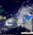
The Tropical Rainfall Measuring Mission (TRMM) satellite passed over that area on July 21 at 0136 UTC (July 20 at 9:36 p.m. EDT) and captured data used in a rainfall analysis. This rainfall analysis shows that intense rainfall was already affecting southwestern Haiti. Some areas are receiving up to 2 inches of rain per hour as System 97L continues to develop.
Rain rates are created from different instruments aboard TRMM. The rain rates in the center of TRMM images are derived from the TRMM Precipitation Radar, the only space borne radar of its kind, while those in the outer portion are from the TRMM Microwave Imager. The rain rates are then overlaid on infrared data from the TRMM Visible Infrared Scanner to create an entire image. Today's image included infrared data from the Geostationary Operational Environmental Satellite (GOES-13) to fill in locations not viewed by the TRMM satellite. The TRMM rainfall images and GOES images are created at NASA's Goddard Space Flight Center, in Greenbelt, Md.
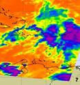
On July 21 at 6:23 UTC (2:23 a.m. EDT) NASA's Aqua satellite flew over System 97L and using the technology from the Atmospheric Infrared Sounder (AIRS) instrument, captured a view of System 97L's cold cloud top temperatures and warm ocean surface waters below it.
The AIRS image showed some high thunderstorms (indicating strong storms) that make up System 97L were over Haiti, the Dominican Republic, Puerto Rico, and the Virgin Islands. The bulk of the thunderstorm activity was east of Puerto Rico and over the Virgin Islands at the time the Aqua satellite flew overhead. Thunderstorm cloud tops were colder than -63 Fahrenheit, while ocean surface temperatures were warmer than the 80 degrees Fahrenheit needed to power a tropical cyclone.
By 8 a.m. EDT on July 21, satellite data indicated that the shower activity associated with System 97L was becoming less organized. The National Hurricane Center (NHC) noted that a tropical depression is not expected to form today, but conditions are still favorable for that development.
System 97L is moving west-northwest near 10 mph, and will affect the Bahamas tomorrow, Thursday, July 22. The NHC still maintains a 60 percent chance that System 97L will develop into a tropical depression in the next 48 hours.
Meanwhile, locally heavy rains and gusty winds will continue to affect the Virgin Islands, Puerto Rico and Hispaniola today. The NHC said that the gusty winds and heavy rains "will likely spread over the Turks and Caicos Islands and the Bahamas during the next couple of days. The heavy rains could cause life-threatening flash floods and mud slides in mountainous areas."
Source: NASA/Goddard Space Flight Center
Articles on the same topic
- GOES-13 sees Tropical Depression 3 form in the Atlantic: Bahamas, Florida under warningsThu, 22 Jul 2010, 18:44:55 UTC
Other sources
- GOES-13 sees Tropical Depression 3 form in the Atlantic: Bahamas, Florida under warningsfrom Science BlogThu, 22 Jul 2010, 19:42:24 UTC
- GOES-13 sees Tropical Depression 3 form in the Atlantic: Bahamas, Florida under warningsfrom PhysorgThu, 22 Jul 2010, 19:08:16 UTC
- NASA satellites see System 97L serve up a soakingfrom Science BlogWed, 21 Jul 2010, 21:49:11 UTC
- NASA satellites see System 97L serve up a soakingfrom PhysorgWed, 21 Jul 2010, 21:28:25 UTC

