NASA satellite sees Tropical Storm Mindulle make landfall in Vietnam
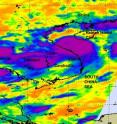
Tropical Storm Mindulle came ashore in central Vietnam today, August 24 and brought heavy rainfall and gusty winds with it. NASA's Aqua satellite captured strong convection and thunderstorms in Mindulle's center before it made landfall close to the city of Vinh, south of the capital. Now, Mindulle is encountering rugged, mountainous terrain as it continues to move inland. On August 23 at 18:35 UTC (2:23 p.m. EDT) NASA's Atmospheric Infrared Sounder (AIRS) instrument captured an infrared image of Mindulle's cloud temperatures. The image showed a rounded, compact cyclone, whose center was close to the Vietnam coast. The strongest convection (and thunderstorms) appeared as a large circle in the inside of the storm and indicated highest cloud tops as cold as or colder than -63 Fahrenheit.
At 1200 UTC (8 a.m. EDT) on August 24, Mindulle's center came ashore. Mindulle had maximum sustained winds near 46 mph (40 knots) and higher gusts. It was located near 19.2 North and 105.2 East, just south of the city of Vinh, and about 115 miles south-southwest of Hanoi, Vietnam. Mindulle continues to track west-northwestward at about 9 mph (8 knots), and is expected to dissipate sometime on Wednesday, August 25.
At the Vinh Airport at 9:30 a.m. EDT on August 24 weather conditions included heavy rain, temperature near 75 degrees Fahrenheit, winds at 18 mph from the south-southwest, and air pressure at 29.31 inches and rising, which indicates that the low-level center of Mindulle was already moving west of Vinh at that time. Although Mindulle's rains may cause flooding, they can be beneficial to various reservoirs in Vietnam that are deficient in water.
Mindulle's rainfall was covering most of Vietnam stretching from the city of Hai Phong in the north, all the way south to the city of Tua Hoa. Mindulle's rainfall also extended west into Laos, Thailiand and Cambodia, and was moving toward those countries today.
Source: NASA/Goddard Space Flight Center
Other sources
- NASA satellite sees Tropical Storm Mindulle make landfall in Vietnamfrom Science BlogTue, 24 Aug 2010, 18:35:11 UTC
- NASA satellite sees Tropical Storm Mindulle make landfall in Vietnamfrom PhysorgTue, 24 Aug 2010, 18:21:15 UTC
