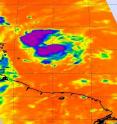
NASA infrared data sees convection building in Fiona's clouds
Infrared satellite imagery from NASA's Aqua satellite showed some strong convection building in Tropical Storm Fiona, and her maximum sustained winds increased from 40 mph yesterday to 60 mph this morning The Atmospheric Infrared Sounder (AIRS) instrument on NASA's Aqua satellite captured an infrared image of Fiona's cold cloud tops on August 31 at 1:05 p.m. EDT and showed two major areas of strong convection (rapidly rising air that forms the thunderstorms that power a tropical cyclone) north and south of the center of circulation. Some of the cloud tops were are cold as -63 degrees Fahrenheit.
Fiona is intensifying as it approaches the Northern Leeward Islands today, so there are watches and warnings in place. A Tropical Storm Warning is in effect for St. Martin and St. Barthelemy. A Tropical Storm Watch is in effect for Antigua, Barbuda, Montserrat, St. Kitts, Nevis, and Anguilla and St. Maarten, Saba, and St. Eustatius.
At 8 a.m. EDT on September 1, Fiona's maximum sustained winds were near 60 mph. It was about 70 miles northeast of Barbuda, near 18.2 North and 60.9 West. It was moving west-northwest near 15 mph with a minimum central pressure of 998 millibars.
The National Hurricane Center noted that tropical storm conditions could spread over portions of the Northern Leeward Islands later this morning and afternoon, and rainfall accumulations of 1 to 3 inches with isolated maximum amounts of 5 inches can be expected over portions of the Northern Leeward Islands.
Source: NASA/Goddard Space Flight Center
Articles on the same topic
- NASA imagery reveals a weaker, stretched out FionaFri, 3 Sep 2010, 18:22:40 UTC
- Bermuda in warnings as the GOES-13 Satellite catches Fiona approachingThu, 2 Sep 2010, 20:38:17 UTC
- Infrared NASA image shows strong convection in new Atlantic Depression 9Wed, 1 Sep 2010, 19:08:44 UTC
- NASA's Terra Satellite captures 3 tropical cyclones in the northwestern Pacific OceanTue, 31 Aug 2010, 19:43:15 UTC
- GOES-13 catches 3 tropical cyclones thrashing through the AtlanticTue, 31 Aug 2010, 19:43:13 UTC
Other sources
- NASA imagery reveals a weaker, stretched out Fionafrom PhysorgFri, 3 Sep 2010, 18:49:10 UTC
- NASA imagery reveals a weaker, stretched out Fionafrom Science BlogFri, 3 Sep 2010, 18:42:11 UTC
- Bermuda in warnings as the GOES-13 Satellite catches Fiona approachingfrom PhysorgThu, 2 Sep 2010, 21:22:00 UTC
- Bermuda in warnings as the GOES-13 Satellite catches Fiona approachingfrom Science BlogThu, 2 Sep 2010, 21:21:14 UTC
- NASA infrared data sees convection building in Fiona's cloudsfrom PhysorgWed, 1 Sep 2010, 20:56:26 UTC
- NASA spots ninth system of busy storm yearfrom UPIWed, 1 Sep 2010, 20:14:32 UTC
- Infrared NASA image shows strong convection in new Atlantic Depression 9from PhysorgWed, 1 Sep 2010, 20:14:22 UTC
- Infrared NASA image shows strong convection in new Atlantic Depression 9from Science BlogWed, 1 Sep 2010, 19:49:10 UTC
- NASA infrared data sees convection building in Fiona’s cloudsfrom Science BlogWed, 1 Sep 2010, 18:42:11 UTC
- GOES-13 catches 3 tropical cyclones thrashing through the Atlanticfrom PhysorgTue, 31 Aug 2010, 20:28:30 UTC
- GOES-13 catches 3 tropical cyclones thrashing through the Atlanticfrom Science BlogTue, 31 Aug 2010, 20:15:32 UTC
- GOES-13 catches 3 tropical cyclones thrashing through the Atlanticfrom Science BlogTue, 31 Aug 2010, 20:15:20 UTC
- NASA’s Terra Satellite captures 3 tropical cyclones in the northwestern Pacific Oceanfrom Science BlogTue, 31 Aug 2010, 20:15:01 UTC
- NASA's Terra Satellite captures 3 tropical cyclones in the northwestern Pacific Oceanfrom PhysorgTue, 31 Aug 2010, 19:42:23 UTC
