NASA's Aqua sees Tropical Storm Vince about to U-turn away from Australia
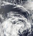
Building high pressure is expected to make Tropical Storm Vince do a U-turn in the Southern Indian Ocean and take a westward track away from Western Australia. Two instruments on NASA's Aqua satellite looked at Vince's clouds this morning before Vince's forecast U-turn. From its vantage point in space, Aqua passed over Tropical Storm Vince on January 14 at 06:20 UTC (1:20 a.m. EST/2:20 p.m. Australia/Perth time) and the Moderate Resolution Spectroradiometer (MODIS) instrument captured a visible image that showed the bulk of Vince's thunderstorms southwest of the storm's center due to moderate wind shear. Another instrument on Aqua looked at the organization of thunderstorms around Vince's center.
Satellite imagery shows that the low level circulation center is now exposed to outside winds, and the strongest convection and thunderstorms are limited to the southwestern quadrant of the storm. Despite the limited strong convection, a satellite image from the Advanced Microwave Scanning Radiometer for EOS (AMSR-E) instrument that also flies aboard NASA's Aqua satellite, showed good organization and tightly curved bands of clouds that are wrapping into the center.
At 1500 UTC (10 a.m. EST/11:00 p.m. Australia/Perth) on Jan. 14, Tropical Storm Vince's maximum sustained winds were down to 39 mph (35 knots/63 km/hr). It was located approximately 350 nautical miles north of Learmonth, Australia, near 16.3 South and 114.6 East. It was moving eastward at 10 mph (9 knots/16 km/hr) and is expected to turn west.
Vince is currently dealing with moderate vertical wind shear (which can tear a storm apart). Winds buffering the tropical storm are blowing between 20 and 30 knots (23 mph/37 km/hr and 34 mph/55 km/hr).
A ridge (an elongated area) of high pressure that is building over Western Australia is expected to push Vince to the west and away from Australia this weekend. By Monday, Vince is forecast to move into cooler waters and weaken.
Source: NASA/Goddard Space Flight Center
Articles on the same topic
- NASA's TRMM Satellite sees Zelia born of System 94PFri, 14 Jan 2011, 22:01:51 UTC
- NASA satellite: Tropical Storm Vania brought heavy rains to southeastern New CaledoniaFri, 14 Jan 2011, 21:32:34 UTC
- NASA's Aqua Satellite sees tropical potential in system 94PFri, 14 Jan 2011, 15:07:19 UTC
- NASA satellites dissect Tropical Storm Vania's clouds and rainfallFri, 14 Jan 2011, 15:07:18 UTC
Other sources
- NASA's Aqua sees Tropical Storm Vince about to U-turn away from Australiafrom PhysorgFri, 14 Jan 2011, 23:00:26 UTC
- NASA's TRMM Satellite sees Zelia born of System 94Pfrom PhysorgFri, 14 Jan 2011, 23:00:25 UTC
- NASA satellite: Tropical Storm Vania brought heavy rains to southeastern New Caledoniafrom PhysorgFri, 14 Jan 2011, 23:00:24 UTC
- NASA’s TRMM Satellite sees Zelia born of System 94Pfrom Science BlogFri, 14 Jan 2011, 22:31:32 UTC
- NASA satellite: Tropical Storm Vania brought heavy rains to southeastern New Caledoniafrom Science BlogFri, 14 Jan 2011, 22:31:31 UTC
- NASA’s Aqua sees Tropical Storm Vince about to U-turn away from Australiafrom Science BlogFri, 14 Jan 2011, 22:31:30 UTC
- NASA's Aqua Satellite sees tropical potential in system 94Pfrom PhysorgFri, 14 Jan 2011, 15:02:45 UTC
- NASA satellites dissect Tropical Storm Vania's clouds and rainfallfrom PhysorgFri, 14 Jan 2011, 15:00:47 UTC
- NASA satellites dissect Tropical Storm Vania’s clouds and rainfallfrom Science BlogFri, 14 Jan 2011, 15:00:25 UTC
- NASA’s Aqua Satellite sees tropical potential in system 94Pfrom Science BlogFri, 14 Jan 2011, 15:00:24 UTC
