NASA sees sixth tropical cyclone form in Atlantic
Tropical Depression 6 developed in the far eastern North Atlantic Ocean and NASA and NOAA satellites provided infrared and visible views at the storm. The Global Precipitation Measurement mission or GPM core observatory satellite collected data as the newest Atlantic Ocean tropical depression was forming on August 16, 2016 at 4:31 p.m. EDT (2031 UTC). GPM data showed that the forming tropical cyclone was getting organized. A strong band of rainfall south of the center of the low's circulation was shown with data from GPM's Microwave Imager (GMI) and Dual-Frequency Precipitation Radar (DPR) instruments. DPR measurements found that an intense shower in this band was dropping rain at a rate of over 155 mm (6.1 inches) per hour.
GPM's radar data (DPR Ku Band) data was used to create a 3-D slice through the forming tropical depression. The 3-D image, created at NASA's Goddard Space Flight Center in Greenbelt, Md. showed intensity and heights of precipitation in some tall storms reached heights of over 15 km (9.3 miles).
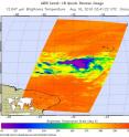
The Atmospheric Infrared Sounder or AIRS instrument that flies aboard NASA's Aqua satellite analyzed the depression within an hour after it formed. AIRS looked at Tropical Depression 6 (TD6) in infrared light on Aug. 16 at 11:41 p.m. EDT (0341 UTC on Aug. 17) gathering temperature data of the system's clouds. Strong thunderstorms were seen north of the center of circulation where cloud top temperatures exceeded minus 63 degrees Fahrenheit (minus 53 degrees Celsius). Storms with temperatures that cold are high in the troposphere and NASA research has shown they have the ability to generate heavy rain.
On Aug. 17 at 11 a.m. EDT the National Hurricane Center discussion noted "The depression's overall cloud pattern and low-level wind field have continued to improve, although cloud tops have warmed considerably near the center since the previous advisory."
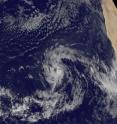
NOAA's GOES-East satellite captured a visible image of Tropical Depression 6 in the far eastern Atlantic on Aug. 17 at 10:45 a.m. EDT (1645 UTC). NOAA manages the GOES series of satellites and the NASA/NOAA GOES Project at NASA's Goddard Space Flight Center in Greenbelt, Maryland uses the satellite data to create images and animations.
At 11 a.m. EDT (1500 UTC) the center of Tropical Depression Six (TD6) was located near 14.0 degrees north latitude and 36.4 degrees west longitude, about 840 miles (1,350 km) west of the Cape Verde Islands. The Cape Verde islands are made up of two small archipelagos, located about 400 miles off of Africa's west coast.
The National Hurricane Center (NHC) said that the depression is moving toward the west-northwest near 15 mph (24 kph) and this motion with some decrease in forward speed is expected during the next couple of days.
Maximum sustained winds are near 35 mph (55 kph) with higher gusts. Slow strengthening is forecast during the next 48 hours, and the depression is likely to become a tropical storm today, Aug. 17.
Source: NASA/Goddard Space Flight Center
Articles on the same topic
- NASA sees examines new tropical storm in infrared lightThu, 25 Aug 2016, 18:04:09 UTC
- Tropical Depression 14W gets absorbed by system 92WThu, 25 Aug 2016, 16:04:25 UTC
- NASA sees a small tropical depression 14WWed, 24 Aug 2016, 17:06:54 UTC
- GPM sees Tropical Depression Kay fading into historyWed, 24 Aug 2016, 17:06:44 UTC
- NASA sees Lionrock strengthen into a typhoonWed, 24 Aug 2016, 16:36:10 UTC
- NASA's GPM observes Tropical Storm Gaston's developmentWed, 24 Aug 2016, 16:05:31 UTC
- NASA satellite spots new tropical depression in Northwestern Pacific OceanTue, 23 Aug 2016, 19:07:00 UTC
- NASA's Aqua Satellite sees Tropical Depression Kay sevoid of strengthTue, 23 Aug 2016, 17:04:40 UTC
- NASA sees Tropical Storm Lionrock sonsolidatingTue, 23 Aug 2016, 16:04:52 UTC
- NASA witnesses Atlantic's Tropical Storm Gaston coming togetherTue, 23 Aug 2016, 16:04:42 UTC
- NASA Sees a Fading Fiona in AtlanticTue, 23 Aug 2016, 16:04:33 UTC
- NASA-NOAA's Suomi NPP Satellite sees two Tropical Cyclones near JapanMon, 22 Aug 2016, 17:34:20 UTC
- NASA sees Tropical Storm Fiona weakening from wind shearMon, 22 Aug 2016, 15:03:47 UTC
- NASA sees Tropical Storm Lionrock south of JapanFri, 19 Aug 2016, 18:04:13 UTC
- NASA spies Tropical Storm Mindulle's southern side strengthFri, 19 Aug 2016, 18:04:06 UTC
- NASA's Terra Satellite sees Tropical Storm Dianmu over VietnamFri, 19 Aug 2016, 18:03:54 UTC
- NASA spots strong convection in strengthening Tropical Storm KayFri, 19 Aug 2016, 15:05:16 UTC
- NASA sees wind shear affecting Tropical Storm FionaFri, 19 Aug 2016, 15:05:08 UTC
- NASA sees Tropical Storm 12W over the open Northwestern Pacific OceanThu, 18 Aug 2016, 19:07:13 UTC
- NASA sees Tropical Depression 10W form near GuamThu, 18 Aug 2016, 19:07:05 UTC
- NASA sees formation of Atlantic Ocean's Tropical Storm FionaThu, 18 Aug 2016, 17:03:51 UTC
- NASA sees Tropical Storm Chanthu moving over northern JapanWed, 17 Aug 2016, 17:06:02 UTC
- NASA sees wind shear affecting Tropical Storm ChanthuWed, 17 Aug 2016, 17:05:44 UTC
- NASA sees Tropical Storm Chanthu east of JapanWed, 17 Aug 2016, 17:05:34 UTC
Other sources
- NASA sees examines new tropical storm in infrared lightfrom PhysorgThu, 25 Aug 2016, 18:01:39 UTC
- Tropical Depression 14W gets absorbed by system 92Wfrom PhysorgThu, 25 Aug 2016, 16:32:19 UTC
- NASA sees a small tropical depression 14Wfrom PhysorgWed, 24 Aug 2016, 20:01:51 UTC
- GPM sees Tropical Depression Kay fading into historyfrom PhysorgWed, 24 Aug 2016, 20:01:50 UTC
- NASA's GPM observes Tropical Storm Gaston's developmentfrom PhysorgWed, 24 Aug 2016, 19:02:06 UTC
- NASA satellite spots new tropical depression in Northwestern Pacific Oceanfrom PhysorgTue, 23 Aug 2016, 19:03:04 UTC
- NASA's Aqua Satellite sees Tropical Depression Kay sevoid of strengthfrom PhysorgTue, 23 Aug 2016, 17:31:30 UTC
- NASA sees a fading Fiona in Atlanticfrom PhysorgTue, 23 Aug 2016, 16:31:45 UTC
- NASA witnesses Atlantic's Tropical Storm Gaston coming togetherfrom PhysorgTue, 23 Aug 2016, 16:31:41 UTC
- NASA sees Tropical Storm Lionrock sonsolidatingfrom PhysorgTue, 23 Aug 2016, 16:31:40 UTC
- NASA-NOAA's Suomi NPP Satellite sees two Tropical Cyclones near Japanfrom PhysorgMon, 22 Aug 2016, 17:31:15 UTC
- NASA sees Tropical Storm Fiona weakening from wind shearfrom PhysorgMon, 22 Aug 2016, 15:31:15 UTC
- Tropical Storm Fiona weakens to tropical depressionfrom UPIMon, 22 Aug 2016, 14:02:58 UTC
- Tropical Storm Fiona steady as two Atlantic disturbances formfrom UPISun, 21 Aug 2016, 18:01:18 UTC
- NASA sees Tropical Storm Lionrock south of Japanfrom PhysorgFri, 19 Aug 2016, 19:31:22 UTC
- NASA's terra satellite sees Tropical Storm Dianmu over Vietnamfrom PhysorgFri, 19 Aug 2016, 19:31:20 UTC
- NASA spies Tropical Storm Mindulle's southern side strengthfrom PhysorgFri, 19 Aug 2016, 19:31:19 UTC
- NASA sees wind shear affecting Tropical Storm Fionafrom PhysorgFri, 19 Aug 2016, 18:31:39 UTC
- NASA spots strong convection in strengthening Tropical Storm Kayfrom PhysorgFri, 19 Aug 2016, 15:01:28 UTC
- NASA sees Tropical Depression 10W form near Guamfrom PhysorgThu, 18 Aug 2016, 19:31:35 UTC
- NASA sees Tropical Storm 12W over the open Northwestern Pacific Oceanfrom PhysorgThu, 18 Aug 2016, 19:01:50 UTC
- NASA sees formation of Atlantic Ocean's Tropical Storm Fionafrom PhysorgThu, 18 Aug 2016, 17:31:25 UTC
- NASA sees sixth tropical cyclone form in Atlanticfrom PhysorgWed, 17 Aug 2016, 17:31:35 UTC
- NASA sees Tropical Storm Chanthu moving over northern Japanfrom PhysorgWed, 17 Aug 2016, 17:01:40 UTC
- NASA sees wind shear affecting Tropical Storm Chanthufrom PhysorgTue, 16 Aug 2016, 18:31:44 UTC
- NASA sees Tropical Storm Chanthu east of Japanfrom PhysorgMon, 15 Aug 2016, 20:01:54 UTC

