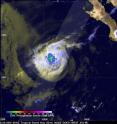
GPM sees Tropical Depression Kay fading into history
The remaining traces of rainfall in weakening Tropical Depression Kay was in a small area when the Global Precipitation Measurement mission or GPM core satellite passed overhead early on Aug. 23. The GPM core observatory satellite captured data as it passed above dissipating tropical storm Kay southwest of Baja on Aug. 22 at 8:41 p.m. EDT (Aug. 23 at 0041 UTC). Data captured by GPM's Dual-Frequency Precipitation Radar (DPR) instrument shows that precipitation was limited to a small area of rain west of the center of the dissipating tropical storm. DPR found that rain was falling at a maximum rate of about 58 mm (2.3 inches) per hour in this small stormy area. GPM is a joint mission between NASA and the Japan Aerospace Exploration Agency
By 5 p.m. EDT, the National Hurricane Center (NHC) reported that Kay had been devoid of deep convection and thunderstorms for about 12 hours. At that time, Kay's center was about 710 miles (1,145 km) west of the southern tip of Baja California, Mexico.
Kay was then classified as a remnant low pressure system and faded into the hurricane history of the Eastern Pacific Hurricane Season.
Source: NASA/Goddard Space Flight Center
Articles on the same topic
- NASA sees examines new tropical storm in infrared lightThu, 25 Aug 2016, 18:04:09 UTC
- Tropical Depression 14W gets absorbed by system 92WThu, 25 Aug 2016, 16:04:25 UTC
- NASA sees a small tropical depression 14WWed, 24 Aug 2016, 17:06:54 UTC
- NASA sees Lionrock strengthen into a typhoonWed, 24 Aug 2016, 16:36:10 UTC
- NASA's GPM observes Tropical Storm Gaston's developmentWed, 24 Aug 2016, 16:05:31 UTC
- NASA satellite spots new tropical depression in Northwestern Pacific OceanTue, 23 Aug 2016, 19:07:00 UTC
- NASA's Aqua Satellite sees Tropical Depression Kay sevoid of strengthTue, 23 Aug 2016, 17:04:40 UTC
- NASA sees Tropical Storm Lionrock sonsolidatingTue, 23 Aug 2016, 16:04:52 UTC
- NASA witnesses Atlantic's Tropical Storm Gaston coming togetherTue, 23 Aug 2016, 16:04:42 UTC
- NASA Sees a Fading Fiona in AtlanticTue, 23 Aug 2016, 16:04:33 UTC
- NASA-NOAA's Suomi NPP Satellite sees two Tropical Cyclones near JapanMon, 22 Aug 2016, 17:34:20 UTC
- NASA sees Tropical Storm Fiona weakening from wind shearMon, 22 Aug 2016, 15:03:47 UTC
- NASA sees Tropical Storm Lionrock south of JapanFri, 19 Aug 2016, 18:04:13 UTC
- NASA spies Tropical Storm Mindulle's southern side strengthFri, 19 Aug 2016, 18:04:06 UTC
- NASA's Terra Satellite sees Tropical Storm Dianmu over VietnamFri, 19 Aug 2016, 18:03:54 UTC
- NASA spots strong convection in strengthening Tropical Storm KayFri, 19 Aug 2016, 15:05:16 UTC
- NASA sees wind shear affecting Tropical Storm FionaFri, 19 Aug 2016, 15:05:08 UTC
- NASA sees Tropical Storm 12W over the open Northwestern Pacific OceanThu, 18 Aug 2016, 19:07:13 UTC
- NASA sees Tropical Depression 10W form near GuamThu, 18 Aug 2016, 19:07:05 UTC
- NASA sees formation of Atlantic Ocean's Tropical Storm FionaThu, 18 Aug 2016, 17:03:51 UTC
- NASA sees Tropical Storm Chanthu moving over northern JapanWed, 17 Aug 2016, 17:06:02 UTC
- NASA sees sixth tropical cyclone form in AtlanticWed, 17 Aug 2016, 17:05:52 UTC
- NASA sees wind shear affecting Tropical Storm ChanthuWed, 17 Aug 2016, 17:05:44 UTC
- NASA sees Tropical Storm Chanthu east of JapanWed, 17 Aug 2016, 17:05:34 UTC
Other sources
- NASA sees examines new tropical storm in infrared lightfrom PhysorgThu, 25 Aug 2016, 18:01:39 UTC
- Tropical Depression 14W gets absorbed by system 92Wfrom PhysorgThu, 25 Aug 2016, 16:32:19 UTC
- NASA sees a small tropical depression 14Wfrom PhysorgWed, 24 Aug 2016, 20:01:51 UTC
- GPM sees Tropical Depression Kay fading into historyfrom PhysorgWed, 24 Aug 2016, 20:01:50 UTC
- NASA's GPM observes Tropical Storm Gaston's developmentfrom PhysorgWed, 24 Aug 2016, 19:02:06 UTC
- NASA satellite spots new tropical depression in Northwestern Pacific Oceanfrom PhysorgTue, 23 Aug 2016, 19:03:04 UTC
- NASA's Aqua Satellite sees Tropical Depression Kay sevoid of strengthfrom PhysorgTue, 23 Aug 2016, 17:31:30 UTC
- NASA sees a fading Fiona in Atlanticfrom PhysorgTue, 23 Aug 2016, 16:31:45 UTC
- NASA witnesses Atlantic's Tropical Storm Gaston coming togetherfrom PhysorgTue, 23 Aug 2016, 16:31:41 UTC
- NASA sees Tropical Storm Lionrock sonsolidatingfrom PhysorgTue, 23 Aug 2016, 16:31:40 UTC
- NASA-NOAA's Suomi NPP Satellite sees two Tropical Cyclones near Japanfrom PhysorgMon, 22 Aug 2016, 17:31:15 UTC
- NASA sees Tropical Storm Fiona weakening from wind shearfrom PhysorgMon, 22 Aug 2016, 15:31:15 UTC
- Tropical Storm Fiona weakens to tropical depressionfrom UPIMon, 22 Aug 2016, 14:02:58 UTC
- Tropical Storm Fiona steady as two Atlantic disturbances formfrom UPISun, 21 Aug 2016, 18:01:18 UTC
- NASA sees Tropical Storm Lionrock south of Japanfrom PhysorgFri, 19 Aug 2016, 19:31:22 UTC
- NASA's terra satellite sees Tropical Storm Dianmu over Vietnamfrom PhysorgFri, 19 Aug 2016, 19:31:20 UTC
- NASA spies Tropical Storm Mindulle's southern side strengthfrom PhysorgFri, 19 Aug 2016, 19:31:19 UTC
- NASA sees wind shear affecting Tropical Storm Fionafrom PhysorgFri, 19 Aug 2016, 18:31:39 UTC
- NASA spots strong convection in strengthening Tropical Storm Kayfrom PhysorgFri, 19 Aug 2016, 15:01:28 UTC
- NASA sees Tropical Depression 10W form near Guamfrom PhysorgThu, 18 Aug 2016, 19:31:35 UTC
- NASA sees Tropical Storm 12W over the open Northwestern Pacific Oceanfrom PhysorgThu, 18 Aug 2016, 19:01:50 UTC
- NASA sees formation of Atlantic Ocean's Tropical Storm Fionafrom PhysorgThu, 18 Aug 2016, 17:31:25 UTC
- NASA sees sixth tropical cyclone form in Atlanticfrom PhysorgWed, 17 Aug 2016, 17:31:35 UTC
- NASA sees Tropical Storm Chanthu moving over northern Japanfrom PhysorgWed, 17 Aug 2016, 17:01:40 UTC
- NASA sees wind shear affecting Tropical Storm Chanthufrom PhysorgTue, 16 Aug 2016, 18:31:44 UTC
- NASA sees Tropical Storm Chanthu east of Japanfrom PhysorgMon, 15 Aug 2016, 20:01:54 UTC
