NASA satellite sees Hurricane Jimena explode in strength over 4 days
Hurricane Warnings are up for the southern Baja California, as powerful Category Four Hurricane Jimena threatens. Jimena developed over the weekend, and the infrared instrument on NASA's Aqua satellite captured that explosive development. A hurricane warning is in effect for the southern portion of the Baja California peninsula from Bahia Magdalena southward on the west coast...and from San Evaristo southward on the east coast, including Cabo San Lucas. Hurricane conditions are expected in the Warning area within 24 hours.
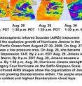
NASA's Atmospheric Infrared Sounder (AIRS) instrument captured the explosive growth of Hurricane Jimena in the Eastern Pacific Ocean from August 27-30, 2009.
On August 27, Jimena was a low pressure area and AIRS showed lower cloud tops and a disorganized system. On August 28, AIRS captured Jimena when she became Tropical Depression 13-E. By 2 a.m. EDT August 29, Jimena was a Tropical Storm, and AIRS saw a better organized, more rounded storm with growing thunderstorms. By 8 p.m. EDT August 29, Jimena became a Hurricane. By 1:30 p.m. August 30, Hurricane Jimena strengthened to a Category Four Hurricane on the Saffir-Simpson Scale and AIRS revealed towering thunderstorms around her center of circulation.
In infrared imagery, NASA's false-colored purple clouds are as cold as or colder than 220 Kelvin or minus 63 degrees Fahrenheit (F). The blue colored clouds are about 240 Kelvin, or minus 27F. Today's satellite imagery indicated Jimena's cloud top temperatures were colder than minus 63F indicating powerful thunderstorms in her center.
At 11 a.m. EDT today, August 31, Jimena had maximum sustained winds near 145 mph making her a powerful Category Four hurricane on the Saffir-Simpson Scale (It is 10 mph under Category Five status). Jimena is a compact storm, with hurricane force winds only extending only 30 miles out, and tropical storm force winds out to 80 miles from the center.
Her center was about 355 miles south-southeast of Cabo San Lucas, Mexico, near 18.0 north and 108.3 west. She was moving northwest near 8 mph, and had a minimum central pressure near 940 millibars.
The National Hurricane Center said in its 11 a.m. EDT update today, "Jimena is expected to produce total rain accumulations of 5 to 10 inches over the southern half of the Baja California peninsula and portions of western Mexico during the next 2 days, with possible isolated maximum amounts of 15 inches. A storm surge along with large and dangerous battering waves will produce significant coastal flooding along the Baja California peninsula."
Source: NASA/Goddard Space Flight Center
Articles on the same topic
- NASA infrared imagery sees landfalling Jimena, weak Kevin and pyrocumulus cloudsTue, 1 Sep 2009, 20:26:41 UTC
Other sources
- Earth from Space: Hurricane Jimenafrom European Space AgencyFri, 4 Sep 2009, 8:35:08 UTC
- Jimena Weakens After Grazing Baja Resortsfrom CBSNews - ScienceWed, 2 Sep 2009, 8:14:07 UTC
- NASA infrared imagery sees landfalling Jimena, weak Kevin and pyrocumulus cloudsfrom PhysorgTue, 1 Sep 2009, 23:21:21 UTC
- Hurricane Jimena Weakens, TS Erika Formsfrom CBSNews - ScienceTue, 1 Sep 2009, 22:21:06 UTC
- NASA satellite sees Hurricane Jimena explode in strength over 4 daysfrom Science BlogMon, 31 Aug 2009, 19:49:08 UTC
- NASA satellite sees Hurricane Jimena explode in strength over 4 daysfrom Science BlogMon, 31 Aug 2009, 18:42:09 UTC
- NASA satellite sees Hurricane Jimena explode in strength over 4 daysfrom PhysorgMon, 31 Aug 2009, 18:28:15 UTC
