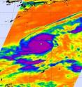
Super typhoon Lupit heading west in the Philippine Sea
Lupit has joined the ranks of super typhoons in the Western Pacific Ocean, and is currently packing maximum sustained winds near 132 mph, down from a previous peak near 149 mph, but still a Category Four strength typhoon. On Monday, October 19 at 11 p.m. local time (Asia/Manila), or 11 a.m. EDT, Super Typhoon Lupit was located about 715 miles east-northeast of Manila, the Philippines, near 19.5 North and 132.0 East. It was moving west-northwest near 11 mph. Lupit is forecast to keep moving westward toward northern Luzon because of a sub-tropical ridge (area of high pressure) to its north.
There are a lot of things happening with the storm, and forecasters at the U.S. Navy's Joint Typhoon Warning Center (JTWC) have seen some changes using animated multispectral satellite imagery. Lupit's eye has become cloud-filled, and since early this morning, forecasters have watched the Lupit's eye decrease from 30 nautical miles to 10 nautical miles.
In addition, JTWC noted that "a slot of dry cooler air has started to wrap to the south of Lupit in the past 12 hours, with a ribbon of dry air continuing on to the eastern half of the system. The dry air has not (yet) started to interact with the core of deepest convection near the low level circulation center."
Forecasters expect a landfall in northern Luzon during the afternoon hours (Asia/Manila Time) on October 22. The U.S. East coast is 12 hours behind local time in Manila.
NASA's Aqua satellite again flew over Super Typhoon Lupit late last night and captured an infrared image of the monster typhoon. Aqua's Atmospheric Infrared Sounder (AIRS) instrument showed high thunderstorm cloud temperatures were colder than minus 63 Fahrenheit indicating a very strong tropical cyclone.
NASA's Terra satellite also passed over Lupit, and captured an image of the storm using the Moderate Imaging Spectroradiometer (MODIS) instrument, that clearly showed Lupit's eye.
Atmospheric conditions are becoming less favorable as Lupit continues moving west, so the storm is expected to weaken as it crosses the Philippine Sea. Residents of northern Luzon are on alert.
Source: NASA/Goddard Space Flight Center
Articles on the same topic
- Philippines breathing easier as Typhoon Lupit turns northFri, 23 Oct 2009, 20:38:02 UTC
- NASA satellites see Typhoon Lupit now bringing more rains to soggy PhilippinesThu, 22 Oct 2009, 19:43:44 UTC
- Luzon expecting a Lupit landfallTue, 20 Oct 2009, 20:08:31 UTC
- NASA satellite tracking Typhoon Lupit on a march toward the northern PhilippinesFri, 16 Oct 2009, 21:57:08 UTC
Other sources
- Philippines breathing easier as Typhoon Lupit turns northfrom PhysorgSat, 24 Oct 2009, 10:42:10 UTC
- Philippines breathing easier as Typhoon Lupit turns northfrom Science BlogSat, 24 Oct 2009, 2:28:25 UTC
- Philippines breathing easier as Typhoon Lupit turns northfrom Science BlogFri, 23 Oct 2009, 21:14:23 UTC
- Satellites see Typhoon Lupit now bringing more rains to soggy Philippinesfrom PhysorgThu, 22 Oct 2009, 20:56:20 UTC
- Luzon expecting a Lupit landfallfrom PhysorgTue, 20 Oct 2009, 22:07:23 UTC
- Luzon expecting a Lupit landfallfrom Science BlogTue, 20 Oct 2009, 21:14:20 UTC
- Super typhoon Lupit heading west in the Philippine Seafrom PhysorgMon, 19 Oct 2009, 21:21:14 UTC
- NASA satellite tracking Typhoon Lupit on a march toward the northern Philippinesfrom Science BlogSat, 17 Oct 2009, 19:42:41 UTC
- NASA satellite tracking Typhoon Lupit on a march toward the northern Philippinesfrom Science BlogFri, 16 Oct 2009, 21:56:13 UTC
- NASA satellite tracking Typhoon Lupit on a march toward the northern Philippinesfrom PhysorgFri, 16 Oct 2009, 21:56:05 UTC

