NASA satellites see Typhoon Lupit now bringing more rains to soggy Philippines
Typhoon Lupit (called Ramil in the Philippines) is already raining over the northern Luzon today, October 22. The storm has unfortunately slowed to 8 mph as it creeps westward, and that's bad news for flood-weary residents, as it means more rainfall for that region. Tropical cyclones Ketsana and Parma caused flooding, devastation and death in the Philippines over the last 30 days, leaving dams overflowing and drenched soils unable to soak up any more rain. Those storms combined were responsible for more than 1,000 deaths in Manila and other parts of Luzon.
At 11:30 a.m. EDT on October 22, (11:30 p.m. Asia/Manila local time) the cities already experiencing rainfall in northern Luzon include Aparri, Calayan, Tuguegarao City, and south as far as Daet, as Lupit moves closer.
Lupit is a Category One Typhoon, with maximum sustained winds near 74 mph. Its center is located 300 nautical miles north-northeast of Manila, the Philippines, but because the storm is so large, its rains are already being felt in the northeast cities of Luzon. Lupit's center was near 18.9 North and 123.5 East. Lupit is moving west near 8 mph, and generating strong surf and seas as high as 32 feet.
Philippine warnings that remain in effect include: Public Storm Warning Signal 3 is in force in the following areas of Luzon: Batanes Group of Islands, Cagayan, Calayan Island, Babuyan Islands, Apayao, Ilocos Norte. Public Storm Warning Signal 2 is in force in the following areas of Luzon: Kalinga, Isabela, Ilocos Sur, Abra, Mt Province, Ifugao, Benguet, La Union, Nueva Vizcaya, Quirino and Aurora. Public Storm Warning Signal 1 is in force in the following areas of Luzon: Pangasinan, Bulacan, Pampanga, Northern Quezon, Polillo Islands, Nueva Ecija, Tarlac and Zambales.
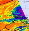
NASA's Aqua satellite again flew just to the west of Typhoon Lupit early this morning Oct. 22 at 5:41 UTC (1:41 p.m. Asia/Manila Time or 1:41 a.m. EDT). Aqua's Atmospheric Infrared Sounder (AIRS) instrument captured the western edge of Lupit, the area of the storm that was already raining on northeast Luzon. The infrared imagery showed that there are still some high thunderstorms, and that means some heavy rainfall coming to the region. Cloud top temperatures were colder than minus 63 Fahrenheit indicating strong thunderstorms in the cyclone.
NASA's Terra satellite passed over Lupit and captured an image of the large storm using the Moderate Imaging Spectroradiometer (MODIS) instrument on October 22 at 0240 UTC (10:40 a.m. local time Asia/Manila) approaching the northern Philippines. The image of Lupit's clouds didn't show an eye, indicating that the storm may be weakening. Dry air crossing over Luzon is beginning to wrap toward Lupit's center, interfering with deep convection ad thunderstorm development, weakening the typhoon. The dry air can't move in quickly enough for residents of Luzon, as the rain is already falling today.
The U.S. Navy's Joint Typhoon Warning Center has amended the forecast track for Lupit, now keeping the center of circulation at sea and passing just northeast of Luzon over the next day or two before curving northwest.
Source: NASA/Goddard Space Flight Center
Articles on the same topic
- Philippines breathing easier as Typhoon Lupit turns northFri, 23 Oct 2009, 20:38:02 UTC
- Luzon expecting a Lupit landfallTue, 20 Oct 2009, 20:08:31 UTC
- Super typhoon Lupit heading west in the Philippine SeaMon, 19 Oct 2009, 19:23:51 UTC
- NASA satellite tracking Typhoon Lupit on a march toward the northern PhilippinesFri, 16 Oct 2009, 21:57:08 UTC
Other sources
- Philippines breathing easier as Typhoon Lupit turns northfrom PhysorgSat, 24 Oct 2009, 10:42:10 UTC
- Philippines breathing easier as Typhoon Lupit turns northfrom Science BlogSat, 24 Oct 2009, 2:28:25 UTC
- Philippines breathing easier as Typhoon Lupit turns northfrom Science BlogFri, 23 Oct 2009, 21:14:23 UTC
- Satellites see Typhoon Lupit now bringing more rains to soggy Philippinesfrom PhysorgThu, 22 Oct 2009, 20:56:20 UTC
- Luzon expecting a Lupit landfallfrom PhysorgTue, 20 Oct 2009, 22:07:23 UTC
- Luzon expecting a Lupit landfallfrom Science BlogTue, 20 Oct 2009, 21:14:20 UTC
- Super typhoon Lupit heading west in the Philippine Seafrom PhysorgMon, 19 Oct 2009, 21:21:14 UTC
- NASA satellite tracking Typhoon Lupit on a march toward the northern Philippinesfrom Science BlogSat, 17 Oct 2009, 19:42:41 UTC
- NASA satellite tracking Typhoon Lupit on a march toward the northern Philippinesfrom Science BlogFri, 16 Oct 2009, 21:56:13 UTC
- NASA satellite tracking Typhoon Lupit on a march toward the northern Philippinesfrom PhysorgFri, 16 Oct 2009, 21:56:05 UTC

