System 92L in Atlantic getting organized in a tropical way
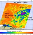
An area of low pressure referred to by meteorologists as "System 92L" in the Atlantic Ocean seems ripe for development and NASA infrared satellite imagery revealed areas in the low that have strong convection. Convection refers primarily to atmospheric motions in the vertical direction, or rising warm air that condenses and forms clouds. NASA's Aqua satellite flew over the low pressure area on June 14 at 04:29 UTC (12:29 a.m. EDT). The Atmospheric Infrared Sounder (AIRS) instrument detects heat (and cold), and provides a great snapshot of the temperatures associated with the developing low and the ocean waters that lay in its path.
The low pressure area getting better organized and AIRS infrared imagery revealed there are some high, cold, strong thunderstorms in some of the areas of the low. AIRS data showed that some of the cloud tops are as cold, or colder than -74 Fahrenheit (- 58 Celsius and 215 Kelvin). AIRS also provided a look at the sea surface temperatures in the direction that System 92L is moving, and noticed they are about 80 degrees Fahrenheit or warmer (300 Kelvin or 27 Celsius) , warm enough to support tropical cyclone development.
At 8 a.m. EDT on June 14, System 92L was located about 1425 miles east-southeast of the Windward Islands. Looking at a map of the Atlantic, the low also sits far north of the eastern-most tip of Brazil. The center is difficult to determine but appears on NASA satellite imagery to be between 4 and 8 degrees North latitude and between 32 and 40 degrees West longitude.
The National Hurricane Center notes that "Environmental conditions are expected to remain conducive for development during the next day or so as the system moves west-northwestward to northwestward at about 15 mph. The low developed on Sunday, June 13 and was about 975 miles southwest of the southernmost Cape Verde Islands.
Because of favorable conditions for development, System 92L has a "high chance" for developing into a tropical depression, according to the National Hurricane Center. Forecasters there are giving 92L a "60 percent chance" of development in the next two days.
Meanwhile, in the Eastern Pacific Ocean, there are two areas that have small chances of development in the next 48 hours, but forecasters are keeping an eye on both of them.
The first area of cloudiness and showers are associated with a broad area of low pressure, that's about 350 miles west-southwest of Acapulco, Mexico. This low is poorly organized, although it may develop slowly. Currently the National Hurricane Center gives it a "20 percent chance" of developing in the next 48 hours. The second area lies near the Gulf of Tehuantepec and is also poorly organized. If this low develops, it is expected to occur slowly. This system also has a 20 percent chance of developing into a tropical depression in the next 48 hours.
Hurricane season has truly started. Forecasters now have lows in both the Atlantic and Eastern Pacific Ocean to keep an eye on this week.
Source: NASA/Goddard Space Flight Center
Articles on the same topic
- NASA watching System 94L over Lesser Antilles for developmentFri, 18 Jun 2010, 20:03:46 UTC
- System 92L's chances for tropical development extremely diminishedWed, 16 Jun 2010, 21:04:13 UTC
Other sources
- NASA watching System 94L over Lesser Antilles for developmentfrom PhysorgFri, 18 Jun 2010, 21:31:03 UTC
- NASA watching System 94L over Lesser Antilles for developmentfrom Science BlogFri, 18 Jun 2010, 20:30:42 UTC
- System 92L’s chances for tropical development extremely diminishedfrom Science BlogWed, 16 Jun 2010, 22:31:39 UTC
- System 92L's chances for tropical development extremely diminishedfrom PhysorgWed, 16 Jun 2010, 21:30:33 UTC
- System at sea could form first Atlantic tropical stormfrom PhysorgMon, 14 Jun 2010, 20:02:09 UTC
- System 92L in Atlantic getting organized in a tropical wayfrom Science BlogMon, 14 Jun 2010, 17:00:28 UTC
- System 92L in Atlantic getting organized in a tropical wayfrom PhysorgMon, 14 Jun 2010, 16:40:11 UTC
- In North Atlantic, researchers find a sea of garbagefrom PhysorgSun, 13 Jun 2010, 15:20:37 UTC
- "Ominous" Pre-Katrina Conditions Seen in Atlanticfrom National GeographicFri, 11 Jun 2010, 22:21:25 UTC
- North Atlantic plastic debris study startsfrom UPIThu, 10 Jun 2010, 18:14:05 UTC
