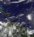
System 92L's chances for tropical development extremely diminished
The possibility that System 92L in the Atlantic Ocean will bloom into the Atlantic's first tropical storm is now minimal because of strong westerly winds. The GOES-13 satellite captured a visible image of System 92L on June 16 at 11:45 UTC (7:45 a.m. EDT) and it appeared as a small rounded area of cloudiness in the Atlantic.
GOES-13 was launched by NASA and is now operated by the National Oceanic and Atmospheric Administration (NOAA). NASA's GOES Project at the Goddard Space Flight Center in Greenbelt, Md. created the latest satellite image.
The showers and thunderstorms associated with the low pressure area known as System 92L have increased, but "strong westerly winds at upper levels are not making conditions favorable for tropical cyclone formation," according to the National Hurricane Center.
System 92L is located about 725 miles east of the Lesser Antilles. It is moving west-northwestward near 15 mph and will move northwestward.
The National Hurricane Center now gives System 92L a meager ten percent chance of becoming a tropical cyclone during the next 48 hours because of those strong westerly winds.
Source: NASA/Goddard Space Flight Center
Articles on the same topic
- NASA watching System 94L over Lesser Antilles for developmentFri, 18 Jun 2010, 20:03:46 UTC
- System 92L in Atlantic getting organized in a tropical wayMon, 14 Jun 2010, 16:44:00 UTC
Other sources
- NASA watching System 94L over Lesser Antilles for developmentfrom PhysorgFri, 18 Jun 2010, 21:31:03 UTC
- NASA watching System 94L over Lesser Antilles for developmentfrom Science BlogFri, 18 Jun 2010, 20:30:42 UTC
- System 92L’s chances for tropical development extremely diminishedfrom Science BlogWed, 16 Jun 2010, 22:31:39 UTC
- System 92L's chances for tropical development extremely diminishedfrom PhysorgWed, 16 Jun 2010, 21:30:33 UTC
- System at sea could form first Atlantic tropical stormfrom PhysorgMon, 14 Jun 2010, 20:02:09 UTC
- System 92L in Atlantic getting organized in a tropical wayfrom Science BlogMon, 14 Jun 2010, 17:00:28 UTC
- System 92L in Atlantic getting organized in a tropical wayfrom PhysorgMon, 14 Jun 2010, 16:40:11 UTC
- In North Atlantic, researchers find a sea of garbagefrom PhysorgSun, 13 Jun 2010, 15:20:37 UTC
- "Ominous" Pre-Katrina Conditions Seen in Atlanticfrom National GeographicFri, 11 Jun 2010, 22:21:25 UTC
- North Atlantic plastic debris study startsfrom UPIThu, 10 Jun 2010, 18:14:05 UTC
