NASA satellites see Typhoon Megi poised for southeastern China landfall
Typhoon Megi has run into winds that are weakening the storm, but it is forecast to make landfall in southeastern China late at night (EDT) on Oct. 22 (11 a.m. local time Hong Kong, Oct. 23) as a Category One Typhoon. NASA satellites have been monitoring the storm's rainfall, changing cloud cover, and changing eye as it weakens. The Tropical Rainfall Measuring Mission (TRMM) satellite traveled directly above Megi on October 21 at 1401 UTC (10:01 a.m. EDT) when wind speeds were estimated to be about 100 knots (~115 mph). Megi caused at least 27 deaths in the Philippines and is now headed directly toward southern China when the TRMM satellite captured data on the storm's rainfall.
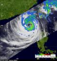
TRMM's Microwave Imager (TMI) and Precipitation Radar (PR) data were used to make a precipitation analysis that was overlaid on a TRMM Infrared image at NASA's Goddard Space Flight Center in Greenbelt, Md. The TRMM image showed Megi contained powerful thunderstorms rotating around a large distinct circular eye. The TRMM rainfall analysis showed that the heaviest rainfall, falling at about 2 inches per hour was located in bands of thunderstorms to the east of Megi's eye.
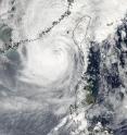
Because wind shear has increased today, Oct. 22, the storm continues to weaken. Satellite data indicates that convection (rapidly rising air that form the thunderstorms that power the typhoon) is weaker today than yesterday, also indicating a weakening storm. Further, the large eye has now completely filled with clouds.
On Friday, Oct. 22 at 1500 UTC (11 a.m. EDT) Typhoon Megi's maximum sustained winds had decreased to 90 knots (103 mph), making Megi a Category Two typhoon on the Saffir-Simpson Scale. It was located about 235 nautical miles east of Hong Kong near 22.6 North and 118.3 East. It was moving North at 7 mph (6 knots) and is expected to make landfall in southeastern China by 11 p.m. tonight (EDT), or 11 a.m. on Saturday, Oct. 23 local time in Hong Kong.
The Joint Typhoon Warning Center forecasts a landfall late at night on Oct. 22 (Eastern Daylight Time). After landfall, Megi is expected to dissipate quickly and merge with a stationary frontal boundary.
Source: NASA/Goddard Space Flight Center
Articles on the same topic
- 3 NASA satellites capture Typhoon Megi strengthening againWed, 20 Oct 2010, 19:02:51 UTC
Other sources
- NASA satellites see Typhoon Megi poised for southeastern China landfallfrom Science BlogFri, 22 Oct 2010, 23:20:40 UTC
- NASA satellites see Typhoon Megi poised for southeastern China landfallfrom PhysorgFri, 22 Oct 2010, 23:20:22 UTC
- 3 NASA satellites capture Typhoon Megi strengthening againfrom Science BlogWed, 20 Oct 2010, 21:00:40 UTC
- 3 NASA satellites capture Typhoon Megi strengthening againfrom PhysorgWed, 20 Oct 2010, 20:00:41 UTC
- Typhoon Megi's heavy rainfall witnessed by NASA as it moves into the South China Seafrom PhysorgWed, 20 Oct 2010, 15:32:35 UTC
- Green: On Our Radar: A Super Typhoonfrom NY Times ScienceTue, 19 Oct 2010, 15:50:59 UTC
- What Makes a Storm a Super-Typhoon?from Live ScienceTue, 19 Oct 2010, 1:32:03 UTC

