NASA's infrared image of major Hurricane Adrian reveals its stormy life's blood
Strong thunderstorms are the life's blood of tropical cyclones, and infrared and radar satellite data from NASA today confirms that the eastern Pacific Ocean's first hurricane has plenty of them and they're over 9 miles high. Adrian exploded in growth overnight from a tropical storm on June 8 to a major hurricane today. NASA's Aqua satellite flew over Hurricane Adrian this morning at 8:29 UTC (1:59 a.m. EDT), and the Atmospheric Infrared Sounder instrument took an infrared snapshot of the storm's many strong thunderstorms and warm ocean water below.
The infrared data suggests that Adrian has an eye, as in the center of circulation on the infrared image is a blue-colored U-shape. Because AIRS imagery is false-colored, purple represents the highest, coldest cloud tops and strongest thunderstorms, and blue represents lower, warmer cloud tops. The coldest cloud top temperatures are as cold as or colder than -63 Fahrenheit (-52 Celsius). The blue area in the center of the larger area of purple in the imagery suggests that some overcast clouds are obscuring an eye. Other satellite data has confirmed the eye.
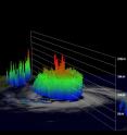
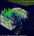
The Tropical Rainfall Measuring Mission (TRMM) satellite captured rainfall and cloud data from Hurricane Adrian when it passed directly above on June 9, 2011 at 0714 UTC (3:14 a.m. EDT). The increasingly powerful hurricane had sustained winds estimated to be close to 80 kts (~92 mph) at the time of this pass. TRMM's Precipitation Radar (PR) instrument revealed that beneath the clouds there were intense thunderstorms dropping rain at a rate of over 50 mm/hr (~2 inches) in a nearly circular eye wall. The PR also indicated that some thunderstorms in the eye wall were shooting up to heights above 15 km (~9.3 miles).
At 11 a.m. EDT (8 a.m. PDT), Hurricane Adrian had maximum sustained winds near 115 mph, making it a category three on the Saffir-Simpson scale and the season's first major hurricane as well as the first hurricane in the eastern Pacific. Hurricane force winds extend out from the center by up to 30 miles (45 km) and tropical storm force winds extend outward up to 80 miles (130 km).
Adrian was about 440 miles (710 km) south-southeast of Cabo Corrientes, Mexico near 14.2 North and 104.1 West. It was moving west-northwest near 9 mph (15 kmh) with a minimum central pressure of 960 millibars.
Hurricane Adrian's strength and proximity to land means that Southwestern Mexico's coastline will continue to get large swells and rip currents through the early part of the weekend. Adrian is expected to enter cooler waters by the early weekend which will sap some of his strength. The National Hurricane Center forecasts Adrian to continue moving out to sea and away from land.
Source: NASA/Goddard Space Flight Center
Articles on the same topic
- NASA sees heavy rainfall in Tropical Storm SarikaFri, 10 Jun 2011, 19:35:45 UTC
- NASA catches system 92W become fifth NW Pacific tropical depressionThu, 9 Jun 2011, 20:37:02 UTC
- A double-satellite NASA-style view of the first tropical storm in eastern Pacific: AdrianWed, 8 Jun 2011, 21:02:46 UTC
- NASA sees a hot tower in first tropical depression of the eastern PacificTue, 7 Jun 2011, 21:02:49 UTC
- Possible first eastern Pacific tropical depression shaping up on NASA imageryTue, 7 Jun 2011, 18:35:52 UTC
Other sources
- NASA sees heavy rainfall in Tropical Storm Sarikafrom PhysorgFri, 10 Jun 2011, 19:00:28 UTC
- NASA's infrared image of major Hurricane Adrian reveals its stormy life's bloodfrom PhysorgThu, 9 Jun 2011, 21:00:46 UTC
- NASA catches system 92W become fifth NW Pacific tropical depressionfrom PhysorgThu, 9 Jun 2011, 20:31:14 UTC
- A double-satellite NASA-style view of the first tropical storm in eastern Pacific: Adrianfrom PhysorgWed, 8 Jun 2011, 22:00:25 UTC
- Season's first tropical depression formsfrom UPIWed, 8 Jun 2011, 3:30:35 UTC
- Season's first tropical depression formsfrom UPIWed, 8 Jun 2011, 0:00:20 UTC
- NASA sees a hot tower in first tropical depression of the eastern Pacificfrom PhysorgTue, 7 Jun 2011, 21:30:55 UTC
- First Hurricane Of Season Forms In Pacificfrom CBSNews - ScienceTue, 7 Jun 2011, 20:31:29 UTC
- Satellite spots potential Pacific stormfrom UPITue, 7 Jun 2011, 18:30:31 UTC
- Satellite spots potential Pacific stormfrom UPIMon, 6 Jun 2011, 22:00:12 UTC
- Possible first eastern Pacific tropical depression shaping up on NASA imageryfrom PhysorgMon, 6 Jun 2011, 21:30:35 UTC

