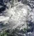
NASA sees Tropical Storm Nock-ten knocking the Philippines
Tropical Storm Nock-ten, formerly tropical depression 10W continues raining on the Philippines, and a NASA satellite image shows the extent of the storm's clouds. A visible image of Tropical Storm 10W, now called Nock-ten was captured on July 26, 2011 at 02:30 UTC or 10:30 a.m. local Asia/Manila time (July 25 at 10:30 p.m. EDT) as its center was moving over the Philippines. The image was taken from the Moderate Resolution Imaging Spectroradiometer (MODIS) that flies on NASA's Terra satellite (it also flies on NASA's Aqua satellite). The center of circulation in the image appears to be near the Cataduanes Island on the eastern side of the Philippines, in the Philippine Sea.
By 1200 UTC (8 p.m. local Asia/Manila time), surface weather reports from Catanduanes confirmed the low level circulation center passed north of the site. The center of Nock-ten is forecast to cross just north of Manila later today, July 26 and early July 27.
At 12:00 UTC (8 a.m. EDT) on July 26, Nock-ten's maximum sustained winds were near 35 knots (40 mph/65 kmh) making it a minimum tropical storm. It was located about 110 nautical miles east of Manila near 14.7 North and 122.6 East. Nock-ten was moving to the west-northwest at 5 knots (6 mph/9 kmh). It is expected to keep moving in that direction because it is following the outside of a ridge (elongated area) of high pressure located north of Luzon (which is north of the storm).
Residents of the central Philippines can expect heavy rainfall, gusty winds and some localized flooding as Nock-ten sweeps across land today and tomorrow. According to the Joint Typhoon Warning Center, Nock-ten should weaken as it moves over land, but re-energize once it enters the South China Sea on July 27.
Source: NASA/Goddard Space Flight Center
Articles on the same topic
- Tropical Storm Muifa appears huge on NASA infrared imageryFri, 29 Jul 2011, 20:35:18 UTC
- Tropical Storm Don analyzed in 3 NASA satellite imagesFri, 29 Jul 2011, 20:35:07 UTC
- NASA identifies the areas of Tropical Storm Muifa's strength Thu, 28 Jul 2011, 19:14:57 UTC
- NASA eyes Tropical Storm Nock-Ten's heavy rains for Hainan Island and VietnamThu, 28 Jul 2011, 19:14:49 UTC
- GOES-13 satellite movie shows formation of Tropical Storm DonThu, 28 Jul 2011, 14:36:02 UTC
- Tropical Depression 11W moving past Yap and GuamWed, 27 Jul 2011, 18:36:23 UTC
- NASA measures heavy rain in Tropical Storm Nock-Ten over PhilippinesWed, 27 Jul 2011, 18:36:13 UTC
- NASA sees dramatic temperatures around Tropical Depression 11WWed, 27 Jul 2011, 15:05:35 UTC
- Tropical Depression 10W bringing rain to the PhilippinesWed, 27 Jul 2011, 15:05:23 UTC
Other sources
- Tropical Storm Don analyzed in 3 NASA satellite imagesfrom PhysorgSat, 30 Jul 2011, 8:30:30 UTC
- NASA identifies the areas of Tropical Storm Muifa's strengthfrom PhysorgThu, 28 Jul 2011, 19:10:42 UTC
- GOES-13 satellite movie shows formation of Tropical Storm Donfrom PhysorgThu, 28 Jul 2011, 15:30:45 UTC
- NASA sees Tropical Storm Nock-ten knocking the Philippinesfrom PhysorgWed, 27 Jul 2011, 15:02:23 UTC
- NASA sees dramatic temperatures around Tropical Depression 11Wfrom PhysorgWed, 27 Jul 2011, 15:02:18 UTC
- Tropical Depression 10W bringing rain to the Philippinesfrom PhysorgMon, 25 Jul 2011, 21:00:40 UTC
