NASA eyes Tropical Storm Nock-Ten's heavy rains for Hainan Island and Vietnam
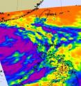
Infrared satellite imagery from NASA's Aqua satellite shows bands of strong thunderstorms wrapping around the center of Tropical Storm Nock-Ten as it makes its way through the South China Sea and two landfalls on Hainan Island and in Vietnam. Bands of strong thunderstorms that make up tropical storm Nock-ten were visible in an infrared image captured on July 28 by the Atmospheric Infrared Sounder (AIRS) instrument that flies on NASA's Aqua satellite. The colder the cloud tops, the higher the thunderstorms and the stronger they are, and cloud top temperatures over a large area of Nock-ten were colder than -63 Fahrenheit (-52 Celsius) and the cloud tops likely extended into the tropopause. High, strong thunderstorms like those also can generate heavy rainfall, up to 2 inches (50 mm) per hour. Those in Nock-ten's path can expect heavy rainfall, local flooding, gusty winds and rough surf along coastal areas.
AIRS imagery has shown that the convection within Nock-ten has intensified as it moves through the warm waters of the South China Sea. It is expected to strengthen a little more with the warm sea surface temperatures feeding it, and wind shear remaining light.
On July 28, at 1500 UTC (11 a.m. EDT) Tropical Storm Nock-ten was already raining on Hainan Island and headed toward another landfall in Vietnam. Its center was still 464 nautical miles east-southeast of Hanoi, Vietnam near 18.2 North and 113.0 East. Nock-ten's sustained winds are near 55 knots (63 mph/101 kmh) and it is moving in a westerly direction at 12 knots (14 mph/22 kmh).
The Joint Typhoon Warning center forecasters expect that the center of Nock-ten will make landfall over Hainan Island, China before July 29 at 1500 UTC (11 a.m. EDT) and weaken a little as it moves over land. However, once it re-emerges over water in the Gulf of Tonkin, it may strengthen a little before making final landfall in Vietnam.
Source: NASA/Goddard Space Flight Center
Articles on the same topic
- Tropical Storm Muifa appears huge on NASA infrared imageryFri, 29 Jul 2011, 20:35:18 UTC
- Tropical Storm Don analyzed in 3 NASA satellite imagesFri, 29 Jul 2011, 20:35:07 UTC
- NASA identifies the areas of Tropical Storm Muifa's strength Thu, 28 Jul 2011, 19:14:57 UTC
- GOES-13 satellite movie shows formation of Tropical Storm DonThu, 28 Jul 2011, 14:36:02 UTC
- Tropical Depression 11W moving past Yap and GuamWed, 27 Jul 2011, 18:36:23 UTC
- NASA measures heavy rain in Tropical Storm Nock-Ten over PhilippinesWed, 27 Jul 2011, 18:36:13 UTC
- NASA sees Tropical Storm Nock-ten knocking the PhilippinesWed, 27 Jul 2011, 15:05:46 UTC
- NASA sees dramatic temperatures around Tropical Depression 11WWed, 27 Jul 2011, 15:05:35 UTC
- Tropical Depression 10W bringing rain to the PhilippinesWed, 27 Jul 2011, 15:05:23 UTC
Other sources
- Tropical Storm Don analyzed in 3 NASA satellite imagesfrom PhysorgSat, 30 Jul 2011, 8:30:30 UTC
- NASA identifies the areas of Tropical Storm Muifa's strengthfrom PhysorgThu, 28 Jul 2011, 19:10:42 UTC
- GOES-13 satellite movie shows formation of Tropical Storm Donfrom PhysorgThu, 28 Jul 2011, 15:30:45 UTC
- NASA sees Tropical Storm Nock-ten knocking the Philippinesfrom PhysorgWed, 27 Jul 2011, 15:02:23 UTC
- NASA sees dramatic temperatures around Tropical Depression 11Wfrom PhysorgWed, 27 Jul 2011, 15:02:18 UTC
- Tropical Depression 10W bringing rain to the Philippinesfrom PhysorgMon, 25 Jul 2011, 21:00:40 UTC
