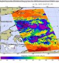
NASA infrared imagery shows new tropical depression coming together
Tropical Depression 06W appeared to be consolidating and coming together in infrared imagery from NASA's Aqua satellite. The storm formed east of the Philippines in the Philippine Sea on July 29, 2016. The Philippine Atmospheric, Geophysical and Astronomical Services Administration known as PAGASA is issuing advisories on Tropical depression 6W (TD6W). PAGASA gave TD6W the local designation of "Carina." For the latest advisory from PAGASA on the movement of Carina, visit: http://www.pagasa.dost.gov.ph/index.php/tropical-cyclones/weather-bulletins.
The Atmospheric Infrared Sounder or AIRS instrument that flies aboard NASA's Aqua satellite analyzed TD6W in infrared light on July 29 at 04:47 UTC (12:47 a.m. EDT) gathering temperature data of the system's clouds. Although the storm appeared somewhat fragmented, strong thunderstorms had formed around the center of circulation, and in fragmented bands northeast of the center. The storm also appears somewhat elongated.
Cloud top temperatures of the strongest storms exceeded minus 63 degrees Fahrenheit (minus 53 degrees Celsius). Storms with temperatures that cold are high in the troposphere and NASA research has shown they have the ability to generate heavy rain.
At 1500 UTC (11 a.m. EDT) on July 29, TD6W was located approximately 394 nautical miles east-southeast of Manila, Philippines. Maximum sustained winds were near 25 knots (28.7 mph/46.3 kph). TD6W has tracked northwestward at 5 knots (5.7 mph/9.2 kph).
AIRS data also showed the sea surface temperatures around TD6W were as warm as 30 Celsius (86 Fahrenheit), warm enough to allow further development. Tropical cyclones need sea surface temperatures of at least 26.6 degrees Celsius (80 degrees Fahrenheit) to maintain intensity. Warmer waters can help a storm intensify, if atmospheric conditions allow.
The Joint Typhoon Warning Center (JTWC) forecast calls for TD6W to continue to track northward then northwestward under the influence of a sub-tropical ridge (elongated area) of high pressure, located to the east. JTWC also expects the depression to strengthen into a tropical storm rapidly.
JTWC noted that the cyclone will begin to interact with the mountainous terrain in Luzon on July 29 and turn north into the South China Sea.
Source: NASA/Goddard Space Flight Center
Articles on the same topic
- NASA sees wind shear relax in Tropical Storm ConsonFri, 12 Aug 2016, 19:04:05 UTC
- NASA measures winds of Tropical Storm ConsonThu, 11 Aug 2016, 19:52:53 UTC
- NASA sees wind shear relax in Tropical Storm ConsonWed, 10 Aug 2016, 15:05:08 UTC
- Satellite sees remnants of Tropical Depression JavierWed, 10 Aug 2016, 14:34:27 UTC
- NASA spots Tropical Storm Javier at southern tip of Baja CaliforniaTue, 9 Aug 2016, 19:04:13 UTC
- NASA measures winds of Tropical Storm OmaisTue, 9 Aug 2016, 19:04:00 UTC
- NASA spots Tropical Storm Conson facing wind shearTue, 9 Aug 2016, 16:03:20 UTC
- NASA sees Tropical Storm Omais weakening near JapanMon, 8 Aug 2016, 20:03:25 UTC
- NASA gets an infrared look at newly formed Tropical Depression 08WMon, 8 Aug 2016, 19:03:26 UTC
- NASA sees Tropical Storm Javier form in the Eastern PacificMon, 8 Aug 2016, 18:04:30 UTC
- NASA infrared imagery shows Tropical Depression Ivette weakeningMon, 8 Aug 2016, 17:34:25 UTC
- NASA sees Tropical Storm Omais in infrared lightFri, 5 Aug 2016, 18:04:54 UTC
- NASA's Terra satellite sees Tropical Storm Ivette holding steadyFri, 5 Aug 2016, 16:36:27 UTC
- Satellite spots new Tropical Storm Ivette far from Baja CaliforniaFri, 5 Aug 2016, 16:36:16 UTC
- NASA sees Tropical Storm Omais form in Northwestern PacificThu, 4 Aug 2016, 17:53:39 UTC
- NASA sees tropical storm Howard weakeningWed, 3 Aug 2016, 16:10:29 UTC
- NASA catches visible and infrared views of Tropical Storm HowardTue, 2 Aug 2016, 16:35:33 UTC
- NASA spots Tropical Storm Howard developing in Eastern PacificMon, 1 Aug 2016, 17:33:27 UTC
- NASA finds Tropical Cyclone Frank fadingMon, 1 Aug 2016, 17:32:54 UTC
Other sources
- NASA measures winds of Tropical Storm Consonfrom PhysorgThu, 11 Aug 2016, 20:11:13 UTC
- NASA sees wind shear relax in Tropical Storm Consonfrom PhysorgWed, 10 Aug 2016, 15:01:30 UTC
- NASA spots Tropical Storm Javier at southern tip of Baja Californiafrom PhysorgTue, 9 Aug 2016, 19:51:26 UTC
- NASA measures winds of Tropical Storm Omaisfrom PhysorgTue, 9 Aug 2016, 19:21:14 UTC
- NASA spots Tropical Storm Conson facing wind shearfrom PhysorgTue, 9 Aug 2016, 16:21:14 UTC
- NASA sees Tropical Storm Omais weakening near Japanfrom PhysorgMon, 8 Aug 2016, 20:01:34 UTC
- NASA gets an infrared look at newly formed Tropical Depression 08Wfrom PhysorgMon, 8 Aug 2016, 19:31:37 UTC
- NASA sees Tropical Storm Javier form in the Eastern Pacificfrom PhysorgMon, 8 Aug 2016, 19:01:29 UTC
- NASA infrared imagery shows Tropical Depression Ivette weakeningfrom PhysorgMon, 8 Aug 2016, 18:02:15 UTC
- NASA sees Tropical Storm Omais in infrared lightfrom PhysorgFri, 5 Aug 2016, 18:31:32 UTC
- Terra satellite sees Tropical Storm Ivette holding steadyfrom PhysorgFri, 5 Aug 2016, 18:01:28 UTC
- NASA sees Tropical Storm Omais form in Northwestern Pacificfrom PhysorgThu, 4 Aug 2016, 18:01:10 UTC
- NASA sees tropical storm Howard weakeningfrom PhysorgWed, 3 Aug 2016, 20:31:42 UTC
- Satellite spots new Tropical Storm Ivette far from Baja Californiafrom PhysorgWed, 3 Aug 2016, 19:31:37 UTC
- NASA catches visible and infrared views of Tropical Storm Howardfrom PhysorgTue, 2 Aug 2016, 17:01:32 UTC
- NASA spots Tropical Storm Howard developing in Eastern Pacificfrom PhysorgMon, 1 Aug 2016, 17:31:29 UTC
- NASA infrared imagery shows new tropical depression coming togetherfrom PhysorgFri, 29 Jul 2016, 19:01:18 UTC
- NASA finds Tropical Cyclone Frank fadingfrom PhysorgThu, 28 Jul 2016, 17:01:30 UTC
