NASA catches visible and infrared views of Tropical Storm Howard
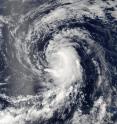
NASA's Aqua satellite provided forecasters with visible and infrared imagery of Tropical Storm Howard as it continued moving west through the waters of the Eastern Pacific Ocean on Aug. 1 and 2. On Aug. 1 at 5:55 p.m. EDT (9:55 p.m. UTC) the Moderate Resolution Imaging Spectroradiometer, or MODIS, instrument aboard NASA's Aqua satellite captured a visible image of Tropical Storm Howard in the eastern Pacific Ocean. The image showed the bulk of thunderstorms east of the center of circulation. The image was created by NASA's MODIS Rapid Response Team and NASA's Goddard Space Flight Center in Greenbelt, Maryland.
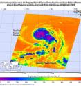
Aqua's Atmospheric Infrared Sounder, or AIRS, instrument gathered infrared data on the storm and vicinity on Aug. 2, 2016, at 6:05 a.m. EDT (10:05 a.m. UTC). AIRS data measured temperatures in Howard's cloud top and the surrounding sea surface.
AIRS data showed that Howard's center is now moving over sea surface temperatures between 77 and 78.8 F (25 and 26 C). The National Hurricane Center noted that Howard should reach waters cooler than 75.2 F (24 C) in about 24 hours.
AIRS data showed Howard's coldest cloud top temperatures were still in excess of minus 63 F (minus 53 C) indicating strong storms with the potential to generate heavy rain.
At 11 a.m. EDT (3 p.m. UTC) on Aug. 2, 2016, the center of Tropical Storm Howard was located near 18.8 degrees north latitude and 128.9 degrees west longitude. That's about 1,255 miles (2,025 km) west of the southern tip of Baja California, Mexico. Because Howard is far from land, there are no coastal watches or warnings in effect.
Maximum sustained winds are near 60 mph (95 kph) with higher gusts. Gradual weakening is forecast to begin by tonight and Wednesday. The estimated minimum central pressure is 999 millibars.
Howard was moving toward the west-northwest near 15 mph (24 kph), and the National Hurricane Center (NHC) said that this general motion is expected to continue for the next couple of days.
Although Howard is moving over cooler waters, vertical wind shear isn't expected to become very strong for another couple of days, so NHC forecasts gradual weakening.
Source: NASA/Goddard Space Flight Center
Articles on the same topic
- NASA sees wind shear relax in Tropical Storm ConsonFri, 12 Aug 2016, 19:04:05 UTC
- NASA measures winds of Tropical Storm ConsonThu, 11 Aug 2016, 19:52:53 UTC
- NASA sees wind shear relax in Tropical Storm ConsonWed, 10 Aug 2016, 15:05:08 UTC
- Satellite sees remnants of Tropical Depression JavierWed, 10 Aug 2016, 14:34:27 UTC
- NASA spots Tropical Storm Javier at southern tip of Baja CaliforniaTue, 9 Aug 2016, 19:04:13 UTC
- NASA measures winds of Tropical Storm OmaisTue, 9 Aug 2016, 19:04:00 UTC
- NASA spots Tropical Storm Conson facing wind shearTue, 9 Aug 2016, 16:03:20 UTC
- NASA sees Tropical Storm Omais weakening near JapanMon, 8 Aug 2016, 20:03:25 UTC
- NASA gets an infrared look at newly formed Tropical Depression 08WMon, 8 Aug 2016, 19:03:26 UTC
- NASA sees Tropical Storm Javier form in the Eastern PacificMon, 8 Aug 2016, 18:04:30 UTC
- NASA infrared imagery shows Tropical Depression Ivette weakeningMon, 8 Aug 2016, 17:34:25 UTC
- NASA sees Tropical Storm Omais in infrared lightFri, 5 Aug 2016, 18:04:54 UTC
- NASA's Terra satellite sees Tropical Storm Ivette holding steadyFri, 5 Aug 2016, 16:36:27 UTC
- Satellite spots new Tropical Storm Ivette far from Baja CaliforniaFri, 5 Aug 2016, 16:36:16 UTC
- NASA sees Tropical Storm Omais form in Northwestern PacificThu, 4 Aug 2016, 17:53:39 UTC
- NASA sees tropical storm Howard weakeningWed, 3 Aug 2016, 16:10:29 UTC
- NASA spots Tropical Storm Howard developing in Eastern PacificMon, 1 Aug 2016, 17:33:27 UTC
- NASA infrared imagery shows new tropical depression coming togetherMon, 1 Aug 2016, 17:33:04 UTC
- NASA finds Tropical Cyclone Frank fadingMon, 1 Aug 2016, 17:32:54 UTC
Other sources
- NASA measures winds of Tropical Storm Consonfrom PhysorgThu, 11 Aug 2016, 20:11:13 UTC
- NASA sees wind shear relax in Tropical Storm Consonfrom PhysorgWed, 10 Aug 2016, 15:01:30 UTC
- NASA spots Tropical Storm Javier at southern tip of Baja Californiafrom PhysorgTue, 9 Aug 2016, 19:51:26 UTC
- NASA measures winds of Tropical Storm Omaisfrom PhysorgTue, 9 Aug 2016, 19:21:14 UTC
- NASA spots Tropical Storm Conson facing wind shearfrom PhysorgTue, 9 Aug 2016, 16:21:14 UTC
- NASA sees Tropical Storm Omais weakening near Japanfrom PhysorgMon, 8 Aug 2016, 20:01:34 UTC
- NASA gets an infrared look at newly formed Tropical Depression 08Wfrom PhysorgMon, 8 Aug 2016, 19:31:37 UTC
- NASA sees Tropical Storm Javier form in the Eastern Pacificfrom PhysorgMon, 8 Aug 2016, 19:01:29 UTC
- NASA infrared imagery shows Tropical Depression Ivette weakeningfrom PhysorgMon, 8 Aug 2016, 18:02:15 UTC
- NASA sees Tropical Storm Omais in infrared lightfrom PhysorgFri, 5 Aug 2016, 18:31:32 UTC
- Terra satellite sees Tropical Storm Ivette holding steadyfrom PhysorgFri, 5 Aug 2016, 18:01:28 UTC
- NASA sees Tropical Storm Omais form in Northwestern Pacificfrom PhysorgThu, 4 Aug 2016, 18:01:10 UTC
- NASA sees tropical storm Howard weakeningfrom PhysorgWed, 3 Aug 2016, 20:31:42 UTC
- Satellite spots new Tropical Storm Ivette far from Baja Californiafrom PhysorgWed, 3 Aug 2016, 19:31:37 UTC
- NASA catches visible and infrared views of Tropical Storm Howardfrom PhysorgTue, 2 Aug 2016, 17:01:32 UTC
- NASA spots Tropical Storm Howard developing in Eastern Pacificfrom PhysorgMon, 1 Aug 2016, 17:31:29 UTC
- NASA infrared imagery shows new tropical depression coming togetherfrom PhysorgFri, 29 Jul 2016, 19:01:18 UTC
- NASA finds Tropical Cyclone Frank fadingfrom PhysorgThu, 28 Jul 2016, 17:01:30 UTC

