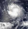
NASA's Terra satellite sees Tropical Storm Ivette holding steady
On Aug. 4 at 3:20 p.m. EDT (1920 UTC), the Moderate Resolution Imaging Spectroradiometer aboard NASA's Terra satellite captured a visible image of Tropical Storm Ivette. The image showed strong storms surrounded the low-level center of circulation and a thick band of powerful thunderstorms extended south of the center, while a fragmented band was north of the center. At 5 a.m. EDT (0900 UTC) on Aug. 5 the center of Tropical Storm Ivette was located near 14.5 north latitude and 129.7 west longitude. Ivette is moving toward the west near 14 mph (22 kph). The National Hurricane Center (NHC) predicts a turn toward the west-northwest at a slightly slower forward speed by Saturday. Maximum sustained winds are near 50 mph (85 kph) with higher gusts. Some slight strengthening is possible during the next day or so.
The low-level center remains exposed to the west and northwest of a loosely curved band of thunderstorms, due to westerly to northwesterly shear.
NHC forecaster Daniel Brown noted, "Although the [vertical wind] shear is not very strong, it appears the small size of the cyclone and perhaps some nearby dry mid-level air in combination with the shear have prevented intensification during the past day."
In two days, cooler waters and increased wind shear are expected to weaken Ivette. NHC forecasts Ivette to become a remnant low pressure area in four or five days.
For updates on Ivette, visit the NHC website at: http://www.nhc.noaa.gov.
Source: NASA/Goddard Space Flight Center
Articles on the same topic
- NASA sees wind shear relax in Tropical Storm ConsonFri, 12 Aug 2016, 19:04:05 UTC
- NASA measures winds of Tropical Storm ConsonThu, 11 Aug 2016, 19:52:53 UTC
- NASA sees wind shear relax in Tropical Storm ConsonWed, 10 Aug 2016, 15:05:08 UTC
- Satellite sees remnants of Tropical Depression JavierWed, 10 Aug 2016, 14:34:27 UTC
- NASA spots Tropical Storm Javier at southern tip of Baja CaliforniaTue, 9 Aug 2016, 19:04:13 UTC
- NASA measures winds of Tropical Storm OmaisTue, 9 Aug 2016, 19:04:00 UTC
- NASA spots Tropical Storm Conson facing wind shearTue, 9 Aug 2016, 16:03:20 UTC
- NASA sees Tropical Storm Omais weakening near JapanMon, 8 Aug 2016, 20:03:25 UTC
- NASA gets an infrared look at newly formed Tropical Depression 08WMon, 8 Aug 2016, 19:03:26 UTC
- NASA sees Tropical Storm Javier form in the Eastern PacificMon, 8 Aug 2016, 18:04:30 UTC
- NASA infrared imagery shows Tropical Depression Ivette weakeningMon, 8 Aug 2016, 17:34:25 UTC
- NASA sees Tropical Storm Omais in infrared lightFri, 5 Aug 2016, 18:04:54 UTC
- Satellite spots new Tropical Storm Ivette far from Baja CaliforniaFri, 5 Aug 2016, 16:36:16 UTC
- NASA sees Tropical Storm Omais form in Northwestern PacificThu, 4 Aug 2016, 17:53:39 UTC
- NASA sees tropical storm Howard weakeningWed, 3 Aug 2016, 16:10:29 UTC
- NASA catches visible and infrared views of Tropical Storm HowardTue, 2 Aug 2016, 16:35:33 UTC
- NASA spots Tropical Storm Howard developing in Eastern PacificMon, 1 Aug 2016, 17:33:27 UTC
- NASA infrared imagery shows new tropical depression coming togetherMon, 1 Aug 2016, 17:33:04 UTC
- NASA finds Tropical Cyclone Frank fadingMon, 1 Aug 2016, 17:32:54 UTC
Other sources
- NASA measures winds of Tropical Storm Consonfrom PhysorgThu, 11 Aug 2016, 20:11:13 UTC
- NASA sees wind shear relax in Tropical Storm Consonfrom PhysorgWed, 10 Aug 2016, 15:01:30 UTC
- NASA spots Tropical Storm Javier at southern tip of Baja Californiafrom PhysorgTue, 9 Aug 2016, 19:51:26 UTC
- NASA measures winds of Tropical Storm Omaisfrom PhysorgTue, 9 Aug 2016, 19:21:14 UTC
- NASA spots Tropical Storm Conson facing wind shearfrom PhysorgTue, 9 Aug 2016, 16:21:14 UTC
- NASA sees Tropical Storm Omais weakening near Japanfrom PhysorgMon, 8 Aug 2016, 20:01:34 UTC
- NASA gets an infrared look at newly formed Tropical Depression 08Wfrom PhysorgMon, 8 Aug 2016, 19:31:37 UTC
- NASA sees Tropical Storm Javier form in the Eastern Pacificfrom PhysorgMon, 8 Aug 2016, 19:01:29 UTC
- NASA infrared imagery shows Tropical Depression Ivette weakeningfrom PhysorgMon, 8 Aug 2016, 18:02:15 UTC
- NASA sees Tropical Storm Omais in infrared lightfrom PhysorgFri, 5 Aug 2016, 18:31:32 UTC
- Terra satellite sees Tropical Storm Ivette holding steadyfrom PhysorgFri, 5 Aug 2016, 18:01:28 UTC
- NASA sees Tropical Storm Omais form in Northwestern Pacificfrom PhysorgThu, 4 Aug 2016, 18:01:10 UTC
- NASA sees tropical storm Howard weakeningfrom PhysorgWed, 3 Aug 2016, 20:31:42 UTC
- Satellite spots new Tropical Storm Ivette far from Baja Californiafrom PhysorgWed, 3 Aug 2016, 19:31:37 UTC
- NASA catches visible and infrared views of Tropical Storm Howardfrom PhysorgTue, 2 Aug 2016, 17:01:32 UTC
- NASA spots Tropical Storm Howard developing in Eastern Pacificfrom PhysorgMon, 1 Aug 2016, 17:31:29 UTC
- NASA infrared imagery shows new tropical depression coming togetherfrom PhysorgFri, 29 Jul 2016, 19:01:18 UTC
- NASA finds Tropical Cyclone Frank fadingfrom PhysorgThu, 28 Jul 2016, 17:01:30 UTC
