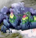
NASA sees Hermine's twin towers
In order for Hermine or any other tropical depression, to intensify there must be a pathway for heat energy from the ocean surface to enter the atmosphere. For Hermine, the conduit may have been one of the two "hot towers" that the Global Precipitation Measurement mission or GPM core satellite observed on Aug. 31 at 4:09 p.m. EDT (2009 UTC). A hot tower is a tall convective cell in which updrafts are strong enough to lift precipitation as high as the top of the troposphere. Updrafts this strong mean that a lot of moisture is condensing in this storm cell as the rain forms. The closer a hot tower is to the low-pressure center of a tropical depression, the more of the heat energy released in that tower is likely to "energize" the tropical depression, leading to a deepening of the low pressure center, and ultimately leading to an acceleration of the winds that circle the low-pressure center.
Two "hot towers" were seen south and east of the center. "One of them was closer to the low pressure center, and so it is more likely to be intimately involved with the strengthening of Hermine," said researcher Owen Kelley of NASA's Goddard Space Flight Center in Greenbelt, Maryland who created a 3-D image of the storm using GPM data.
"Repeated observations of cloud-top heights by geosynchronous satellites showed that these two towers were persistent features, lasting approximately 9 to 12 hours, from the evening of Aug. 31 into the morning of Sept. 1. Research performed by NASA scientists suggests that vigorous convection that persists this long can eject enough energy into the atmosphere to influence the fate of hurricanes and other tropical systems," Kelley said.
Source: NASA/Goddard Space Flight Center
Articles on the same topic
- NASA takes parting look at HermineThu, 8 Sep 2016, 16:06:53 UTC
- NASA sees post-Tropical Storm Hermine south of Long Island, last advisory issuedThu, 8 Sep 2016, 16:06:33 UTC
- NASA sees post-Tropical Cyclone Hermine linger over northeastern USThu, 8 Sep 2016, 16:06:22 UTC
- NASA animation shows landfall and progression of Hurricane HermineFri, 2 Sep 2016, 16:06:38 UTC
- Hermine becomes a hurricane in the Gulf of MexicoThu, 1 Sep 2016, 21:23:09 UTC
- NASA's GPM sees increasingly organized Tropical Storm HermineThu, 1 Sep 2016, 16:35:23 UTC
Other sources
- NASA takes parting look at Herminefrom PhysorgThu, 8 Sep 2016, 16:01:44 UTC
- Scientists use undersea drones to help predict hurricanesfrom PhysorgThu, 8 Sep 2016, 7:31:28 UTC
- Scientists use undersea drones to help predict hurricanesfrom AP ScienceThu, 8 Sep 2016, 5:11:14 UTC
- NASA sees post-Tropical Storm Hermine south of Long Island, last advisory issuedfrom PhysorgWed, 7 Sep 2016, 16:31:20 UTC
- NASA sees post-Tropical Cyclone Hermine linger over northeastern USfrom PhysorgTue, 6 Sep 2016, 20:21:17 UTC
- Post-tropical cyclone Hermine moving toward northeast U.S.from UPITue, 6 Sep 2016, 2:11:21 UTC
- Hermine's storm surge threat shifts to New England coastfrom UPIMon, 5 Sep 2016, 14:31:13 UTC
- Forecasters: Hermine could reach hurricane strength again in Northeastfrom UPISun, 4 Sep 2016, 14:21:16 UTC
- Hermine kills two, ruins beach weekends in northward marchfrom PhysorgSun, 4 Sep 2016, 10:31:30 UTC
- Tropical Storm Hermine maintaining strength as it continues up East Coastfrom UPISat, 3 Sep 2016, 13:31:20 UTC
- Hurricane Season Is Heating Up. So Is the Planet. Coincidence?from NY Times ScienceSat, 3 Sep 2016, 0:21:13 UTC
- Hermine: Storm over Carolinas as Florida cleans up; 1 dead; 250K without powerfrom UPISat, 3 Sep 2016, 0:01:18 UTC
- NASA animation shows landfall and progression of Hurricane Herminefrom PhysorgFri, 2 Sep 2016, 16:01:19 UTC
- NASA sees Hermine's twin towersfrom PhysorgFri, 2 Sep 2016, 15:31:15 UTC
- Hurricane Hermine makes landfall on Florida's Gulf Coastfrom UPIFri, 2 Sep 2016, 10:01:18 UTC
- UW-Madison Scientists Help Fly Global Hawk Drone Into Hermine, Other Hurricanesfrom Newswise - ScinewsFri, 2 Sep 2016, 8:41:21 UTC
- Hurricane Hermine begins assault on Florida's Gulf Coastfrom UPIFri, 2 Sep 2016, 8:11:17 UTC
- Florida facing 'life-threatening' conditions as Hurricane Hermine approachesfrom UPIThu, 1 Sep 2016, 22:31:27 UTC
- Hurricane Hermine Threatens Florida in New Photo from Spacefrom Space.comThu, 1 Sep 2016, 22:11:16 UTC
- Hermine becomes a hurricane in the Gulf of Mexicofrom PhysorgThu, 1 Sep 2016, 21:31:18 UTC
- Hurricane Hermine Threatens Florida in New Photo from Spacefrom Live ScienceThu, 1 Sep 2016, 21:21:19 UTC
- NASA's GPM sees increasingly organized Tropical Storm Herminefrom PhysorgThu, 1 Sep 2016, 16:31:33 UTC
- Florida woman spots alligator swimming down flooded streetfrom UPIThu, 1 Sep 2016, 13:31:28 UTC
- Hurricane warnings for Florida panhandle as Tropical Storm Hermine takes aimfrom UPIThu, 1 Sep 2016, 11:01:48 UTC
- Tropical Storm Hermine picking up steam in Gulf; Florida declares emergenciesfrom UPIWed, 31 Aug 2016, 19:01:19 UTC
- Florida men facing felony charge over viral video of bare-handed alligator capturefrom UPIWed, 31 Aug 2016, 13:31:25 UTC
- Tropical Depression 9 could become hurricane before reaching Floridafrom UPIWed, 31 Aug 2016, 12:01:20 UTC
