A sudden Tropical Storm Grace explodes in far Eastern Atlantic
The latest tropical storm in the Atlantic Ocean may have escaped the notice of most when it formed just before midnight last night so far north and east in the Atlantic, away from where forecasters usually look for forming storms. However, NASA's Aqua satellite and forecasters in the Azores Islands, Portugal and Ireland are watching it closely. Grace came together quickly and her winds were near 65 mph soon after formation. Very early this morning those sustained winds peaked at 70 mph, but fell back to 65 mph. Grace's existence will be short-lived as she's expected to merge with another low pressure area.
It was late last night, October 4 at around 11 p.m. EDT, when Tropical Storm Grace formed about 420 miles northeast of the Azores, near 41.2 North and 20.3 West. By 5 a.m. today, October 5, was speeding north-northeast between the Azores and the British Isles.
Grace had moved to a position about 575 miles southwest of Cork Ireland, and about 590 miles northwest of Lisbon, Portugal near 45.4 North and 16.4 West. Her maximum sustained winds were near 65 mph, and she was speeding northeast near 31 mph. Estimated minimum central pressure is 990 millibars.
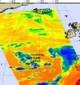
NASA's Aqua satellite AIRS instrument captured an infrared image of Grace's clouds on October 4 at 10:17 a.m. EDT more than 12 hours before she came together as a tropical storm. In the infrared imagery, which measures cloud top temperatures, there were some strong areas of convection, but the storm didn't yet have the signature appearance of a tropical storm. However, the storm quickly organized.
AIRS infrared imagery measures temperatures in the clouds, and found a few of the highest thunderstorm cloud tops were cold as -63 Fahrenheit, indicating some isolated strong convection even before the storm came together.
Grace is expected to be absorbed by a large non-tropical low pressure area over the northeastern Atlantic during the day sometime tomorrow and bring rainfall to Ireland.
Source: NASA/Goddard Space Flight Center
Articles on the same topic
- The Philippines may finally get a break from Tropical Depression ParmaThu, 8 Oct 2009, 20:20:14 UTC
- NASA's TRMM satellite captures Typhoon Melor as it reaches JapanThu, 8 Oct 2009, 19:53:36 UTC
- Typhoon Melor and Tropical Storm Parma mean double trouble in the western PacificWed, 7 Oct 2009, 21:00:57 UTC
- 2 NASA satellites capture monster Super Typhoon MelorMon, 5 Oct 2009, 21:31:37 UTC
- NASA's Aqua Satellite sees Tropical Storm Parma lingering in the Luzon StraitMon, 5 Oct 2009, 20:22:28 UTC
Other sources
- Earth from Space: Typhoon Melorfrom PhysorgFri, 9 Oct 2009, 15:56:23 UTC
- Earth from Space: Typhoon Melorfrom European Space AgencyFri, 9 Oct 2009, 10:14:33 UTC
- NASA's TRMM satellite captures Typhoon Melor as it reaches Japanfrom PhysorgThu, 8 Oct 2009, 21:42:27 UTC
- NASA's TRMM satellite captures Typhoon Melor as it reaches Japanfrom Science BlogThu, 8 Oct 2009, 21:35:15 UTC
- Typhoon Melor and Tropical Storm Parma mean double trouble in the western Pacificfrom Science BlogThu, 8 Oct 2009, 1:35:12 UTC
- Typhoon Melor and Tropical Storm Parma mean double trouble in the western Pacificfrom Science BlogWed, 7 Oct 2009, 22:14:39 UTC
- Typhoon Melor and Tropical Storm Parma mean double trouble in the western Pacificfrom PhysorgWed, 7 Oct 2009, 21:21:17 UTC
- Two NASA satellites capture monster Super Typhoon Melorfrom PhysorgMon, 5 Oct 2009, 21:28:34 UTC
- Aqua Satellite sees Tropical Storm Parma lingering in the Luzon Straitfrom PhysorgMon, 5 Oct 2009, 20:21:22 UTC
