NASA's Aqua Satellite sees Tropical Storm Parma lingering in the Luzon Strait
Related images
(click to enlarge)
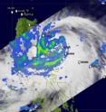
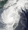
Two instruments on NASA's Aqua satellite captured views of Tropical Storm Parma early today, October 5, while it was almost stationary in the Luzon Strait and it appears that it will sit there for several days. In the early morning hours (EDT) today, October 5, the Moderate Imaging Spectroradiometer (MODIS) instrument on NASA's Aqua satellite captured an image of Typhoon Parma in the Luzon Strait and heading into the South China Sea. Taiwan is located north of the Luzon Strait, and the Philippines are located to its south.
Warnings were still effect in the Philippines today: Public storm warning signal 1 is in force in La Union, Benguet, Mountain Province, Ifugao, Kalinga and Rest of Cagayan. Public storm warning signal 2 is in force in Ilocos Sur, Abra, Apayao, Northern Cagayan, Calayan Group of Islands, Babuyan Group of Islands and Batanes Group of Islands. Finally, Public storm warning signal 3 is in force in Ilocos Norte.
On October 5 at 11 a.m. EDT (1500 UTC), Tropical Storm Parma was located approximately 330 nautical miles east-southeast of Hong Kong, China, near 20.3 North and 119.6 East. Parma is barely moving. Parma had sustained winds near 63 mph (55 knots). Tropical storm-force winds extend as far out as 115 miles from Parma's center, and are generating waves up to 30 feet high, so beaches in both Taiwan and the northern Philippines will experience high and dangerous surf and coastal erosion.
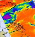
When NASA's Aqua satellite flew over Typhoon Parma today it also captured infrared, microwave and visible images of the typhoon. Aqua's Atmospheric Infrared Sounder (AIRS) instrument analyzed temperatures in Parma's clouds. AIRS revealed that Parma still had some cold high thunderstorm cloud temperatures colder than minus 63 Fahrenheit, indicating some strong convection.
Right now, there's nothing to push Parma west into the South China Sea, so forecasters at the U.S. Navy's Joint Typhoon Warning Center expect it to linger off the northwest coast of Luzon for the next five days. That means more rains and gusty winds for northern Luzon.
There's a lot of uncertainty in the computer forecast models for Parma's path, but he's not expected to become a typhoon again because of upper level winds and the upwelling of cool waters from the ocean bottom. In the meantime, residents of the northern Philippines and Taiwan can expect showers and gusty winds until Parma finds his way.
Source: NASA/Goddard Space Flight Center
Articles on the same topic
- The Philippines may finally get a break from Tropical Depression ParmaThu, 8 Oct 2009, 20:20:14 UTC
- NASA's TRMM satellite captures Typhoon Melor as it reaches JapanThu, 8 Oct 2009, 19:53:36 UTC
- Typhoon Melor and Tropical Storm Parma mean double trouble in the western PacificWed, 7 Oct 2009, 21:00:57 UTC
- 2 NASA satellites capture monster Super Typhoon MelorMon, 5 Oct 2009, 21:31:37 UTC
- A sudden Tropical Storm Grace explodes in far Eastern AtlanticMon, 5 Oct 2009, 20:22:30 UTC
Other sources
- Earth from Space: Typhoon Melorfrom PhysorgFri, 9 Oct 2009, 15:56:23 UTC
- Earth from Space: Typhoon Melorfrom European Space AgencyFri, 9 Oct 2009, 10:14:33 UTC
- NASA's TRMM satellite captures Typhoon Melor as it reaches Japanfrom PhysorgThu, 8 Oct 2009, 21:42:27 UTC
- NASA's TRMM satellite captures Typhoon Melor as it reaches Japanfrom Science BlogThu, 8 Oct 2009, 21:35:15 UTC
- Typhoon Melor and Tropical Storm Parma mean double trouble in the western Pacificfrom Science BlogThu, 8 Oct 2009, 1:35:12 UTC
- Typhoon Melor and Tropical Storm Parma mean double trouble in the western Pacificfrom Science BlogWed, 7 Oct 2009, 22:14:39 UTC
- Typhoon Melor and Tropical Storm Parma mean double trouble in the western Pacificfrom PhysorgWed, 7 Oct 2009, 21:21:17 UTC
- Two NASA satellites capture monster Super Typhoon Melorfrom PhysorgMon, 5 Oct 2009, 21:28:34 UTC
- Aqua Satellite sees Tropical Storm Parma lingering in the Luzon Straitfrom PhysorgMon, 5 Oct 2009, 20:21:22 UTC


