NASA's TRMM satellite captures Typhoon Melor as it reaches Japan
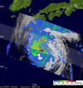
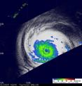
Melor began as a tropical depression back on the 29th of September 2009 about 1000 miles (~1600 km) east-southeast of Guam in the Northern Mariana Islands. Over the next couple of days, the system steadily intensified, first into a tropical storm on the 30th, then into a typhoon on the morning of the 1st of October. At which time, Melor underwent a rapid intensification cycle and quickly reached Category 4 intensity on the night of the 1st with sustained winds estimated at 115 knots (~132 mph) by the Joint Typhoon Warning Center (JTWC) as it moved toward the west-northwest in the direction of the Northern Marianas. Melor underwent minor fluctuations in intensity before passing through the Northern Marianas Islands on the afternoon (local time) of the 3rd where it caused only relatively minor damage. After clearing the islands, Melor strengthened once again, becoming the 3rd super typhoon of the year as it crossed through the central Philippine Sea. Melor reached its peak intensity on the 4th when its sustained winds were estimated at 145 knots (~167 mph) by JTWC. The Tropical Rainfall Measuring Mission satellite (better known as TRMM) has served as a valuable platform for monitoring tropical cyclones since its launch back in 1997, especially over remote parts of the ocean. TRMM captured an image of Melor at 14:29 UTC on October 5, 2009 as the storm was moving west-northwest about 530 miles (~850 km) southeast of Okinawa. The image shows the horizontal distribution of rain intensity inside the storm. The rain rates were obtained from the TRMM Microwave Imager (TMI) and are overlaid on infrared (IR) data from the TRMM Visible Infrared Scanner (VIRS). At the time of that image, although it was a little off of its peak intensity, Melor was still a powerful Category 4 super typhoon with maximum sustained winds estimated at 135 knots (~155 mph) by JTWC. TRMM showed that Melor appears to be in the process of undergoing an eyewall replacement cycle as evidenced by the distinct double eyewall structure. Melor had a nearly complete inner eyewall, which is surrounded by a nearly complete outer eyewall of moderate rain. This type of feature is only found in very powerful, mature tropical cyclones. Also apparent is the nearly symmetrical cirrus cloud shield, which indicates that Melor was still in a favorable low wind shear environment. But, that all changed quickly as the steering currents finally began to recurve Melor toward the north the next day, and in the process, Melor began to weaken steadily.
TRMM captured another image of Melor at 20:06 UTC 6 October (5:06 am 7 October Japan standard time) as it was moving north-northeast towards southern Japan. In the second image, rain rates in the center of the swath were obtained from the TRMM Precipitation Radar (PR), the only spaceborne precipitation radar of its kind. That TRMM image revealed that Melor has lost its symmetrical structure with most of the rain now to the north of the center. This is due to the southwesterly winds that are pushing the storm to the north. The area of light to moderate rain across the top of the TRMM image of October 6 is associated with a stationary front draped across southern Japan. Melor's circulation and moisture are expected to merge with this front and bring heavy rain and strong winds as the system moves northeastward over the main island of Honshu. At the time of this last image, Melor was a Category 2 typhoon with sustained winds estimated at 90 knots (104 mph) by JTWC.
Source: NASA/Goddard Space Flight Center
Articles on the same topic
- The Philippines may finally get a break from Tropical Depression ParmaThu, 8 Oct 2009, 20:20:14 UTC
- Typhoon Melor and Tropical Storm Parma mean double trouble in the western PacificWed, 7 Oct 2009, 21:00:57 UTC
- 2 NASA satellites capture monster Super Typhoon MelorMon, 5 Oct 2009, 21:31:37 UTC
- A sudden Tropical Storm Grace explodes in far Eastern AtlanticMon, 5 Oct 2009, 20:22:30 UTC
- NASA's Aqua Satellite sees Tropical Storm Parma lingering in the Luzon StraitMon, 5 Oct 2009, 20:22:28 UTC
Other sources
- Earth from Space: Typhoon Melorfrom PhysorgFri, 9 Oct 2009, 15:56:23 UTC
- Earth from Space: Typhoon Melorfrom European Space AgencyFri, 9 Oct 2009, 10:14:33 UTC
- NASA's TRMM satellite captures Typhoon Melor as it reaches Japanfrom PhysorgThu, 8 Oct 2009, 21:42:27 UTC
- NASA's TRMM satellite captures Typhoon Melor as it reaches Japanfrom Science BlogThu, 8 Oct 2009, 21:35:15 UTC
- Typhoon Melor and Tropical Storm Parma mean double trouble in the western Pacificfrom Science BlogThu, 8 Oct 2009, 1:35:12 UTC
- Typhoon Melor and Tropical Storm Parma mean double trouble in the western Pacificfrom Science BlogWed, 7 Oct 2009, 22:14:39 UTC
- Typhoon Melor and Tropical Storm Parma mean double trouble in the western Pacificfrom PhysorgWed, 7 Oct 2009, 21:21:17 UTC
- Two NASA satellites capture monster Super Typhoon Melorfrom PhysorgMon, 5 Oct 2009, 21:28:34 UTC
- Aqua Satellite sees Tropical Storm Parma lingering in the Luzon Straitfrom PhysorgMon, 5 Oct 2009, 20:21:22 UTC

