Tropical Storm Laurence set for second Australian landfall
Tropical Storm Laurence tracked through Darwin Australia this weekend before sliding back into the Timor Sea and now Laurence is forecast to make a second landfall in Australia. Laurence is forecast to make landfall north of Wyndham then parallel the coastline while moving over land for the next couple of days. Laurence is forecast to make landfall in the Kimberley region, move southwest through the northern area of the Great Sandy Desert and into the Pilbara region.
At 0900 UTC (4 a.m. ET) on December 14, Tropical Storm Laurence had maximum sustained winds near 52 mph and was located 185 miles west-southwest of Darwin, Australia. That's near 13.5 South and 127.8 East. It was moving west-southwest near 6 mph, in the direction of its second landfall. It was generating waves near 12 feet, so beach erosion along the northern coasts of Western Australia can be expected near where Laurence makes landfall in the next day.
Meanwhile watches and warnings are up. A tropical cyclone warning is in force from Kuri Bay to Wyndham. A tropical cyclone watch is in force from Kuri Bay to Beagle Bay. Gale force winds with gusts up to 62 mph (100 kilometers per hour) are forecast for the northern Kimberley coast tonight. Forecasters expect heavy rainfall in that area tonight and Tuesday as Laurence moves closer to the coast.
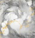
The Moderate Resolution Imaging Spectroradiometer or MODIS instrument on NASA's Terra satellite captured an infrared image of Tropical Storm Laurence on Dec. 14 at 8:43 a.m. ET when it was west-northwest of Darwin, Australia. Satellite imagery showed a disorganized storm.
Hurricane-force wind gusts up to 80 mph (130 kilometers per hour) may develop between Kalumburu and Kuri Bay on December 15. Residents near the communities of Kalumburu, Mitchell Plateau and Faraway Bay should be taking action in preparation for the cyclone's arrival. They are currently under a yellow alert. There is a blue alert in effect for the residents near the communities of Oombulgurri and Kuri Bay.
Source: NASA/Goddard Space Flight Center
Articles on the same topic
- Tropical Cyclone Laurence menaces Northern Australia15 years ago
- Laurence made landfall in Western Australia15 years ago
Other sources
- Laurence still causing warnings and watches in northern west Australiafrom Physorg15 years ago
- Tropical Cyclone Laurence menaces Northern Australiafrom Science Blog15 years ago
- Tropical Cyclone Laurence menaces Northern Australiafrom Physorg15 years ago
- Laurence made landfall in Western Australiafrom Science Blog15 years ago
- Laurence made landfall in Western Australiafrom Physorg15 years ago
- Tropical Storm Laurence set for second Australian landfallfrom Physorg15 years ago


