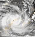
Laurence made landfall in Western Australia
Tropical Cyclone Laurence made landfall in Northwestern Australia this morning (Eastern Time) December 15, 2009. NASA's Aqua satellite captured a visible image of Laurence just before the center of the storm made landfall at 0503 UTC (12:03 a.m. ET). The Moderate Resolution Image Spectroradiometer instrument on Aqua captured the image. At 06:00 UTC (1 a.m. ET) Laurence's center was located near 14.6 South and 125.4 East. Its center was just northeast of Derby, which is located on the coast in the Western Australia territory. Despite it's proximity to the coast, Laurence's winds were near 86 mph, making it a Category One Cyclone. It was moving to the southwest near 7 mph.
Observations from Troughton Island indicated sustained winds as high as 85 mph (74 knots) as Laurence passed 12 hours before.
Laurence is now expected to track deeper into interior Australia and dissipate in the next two days.
Source: NASA/Goddard Space Flight Center
Articles on the same topic
- Laurence still causing warnings and watches in northern west AustraliaThu, 17 Dec 2009, 18:53:28 UTC
- Tropical Cyclone Laurence menaces Northern AustraliaWed, 16 Dec 2009, 21:41:10 UTC
- Tropical Storm Laurence set for second Australian landfallTue, 15 Dec 2009, 1:16:19 UTC
Other sources
- Laurence still causing warnings and watches in northern west Australiafrom Science BlogThu, 17 Dec 2009, 19:42:36 UTC
- Laurence still causing warnings and watches in northern west Australiafrom PhysorgThu, 17 Dec 2009, 18:56:27 UTC
- Tropical Cyclone Laurence menaces Northern Australiafrom Science BlogWed, 16 Dec 2009, 22:28:07 UTC
- Tropical Cyclone Laurence menaces Northern Australiafrom PhysorgWed, 16 Dec 2009, 22:14:09 UTC
- Laurence made landfall in Western Australiafrom Science BlogTue, 15 Dec 2009, 18:28:46 UTC
- Laurence made landfall in Western Australiafrom PhysorgTue, 15 Dec 2009, 18:28:16 UTC
- Tropical Storm Laurence set for second Australian landfallfrom PhysorgTue, 15 Dec 2009, 1:14:18 UTC
