Tropical Cyclone Laurence menaces Northern Australia
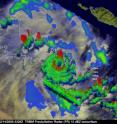
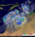
Laurence is still a tropical cyclone even though the storm has made landfall in northern West Australia and is moving over land. The Tropical Rainfall Measuring Mission (TRMM) satellite noticed some powerful and high thunderstorms in Laurence before he made landfall, and the storm is still maintaining intensity for now, but that will wane as the storm continues to interact with the friction caused by traveling over land. The TRMM satellite is a joint mission between NASA and the Japan Aerospace Exploration Agency (JAXA) designed to monitor and study tropical rainfall. When the TRMM satellite passed overhead on 14 December 2009 at 2329 UTC getting rainfall data Tropical Cyclone Laurence was close to hurricane strength. The rotating rain bands around Laurence's center of circulation off the coast of northern Australia were clearly revealed by TRMM's Precipitation Radar (PR) instrument as it peered through obscuring thunderstorm clouds.
Data from TRMM's Precipitation Radar (PR) instrument were used to create a dramatic 3-D view of the storm that showed towering thunderstorms up to 9 miles high around Laurence's developing eye wall.
At 0600 UTC, or 1 a.m. ET today, December 16, Cyclone Laurence was still a powerful cyclone with maximum sustained winds near 103 mph (90 knots) making it a Landfalling Category 2 hurricane on the Saffir-Simpson Scale. Laurence's center was near 16.3 South latitude and 124.2 East longitude about 440 nautical miles from Port Hedland, Australia. Closer to the Laurence's center, and feeling his full hurricane-force wrath today are Koolan Island, Cockatoo Island. Molema Island, Kingfisher Island and the towns of Kimbolton, Derby, Meda on the mainland.
By 1:46 p.m. ET, The Australian Government Bureau of Meteorology reported that Laurence's winds had already started waning and were near 75 knots (86 mph). That means that in 12 hours, Laurence weakened from a Category 2 hurricane to a Category 1 hurricane.
The bulletin on the Australian Bureau of Meteorology website said "Severe Tropical Cyclone Laurence has crossed the Kimberley coast north northeast of Derby as a small but intense system." Laurence had a minimum central pressure of 1003 millibars and was near 16.6 South and 124.1 East, northeast of Kimbolton, and moving slowly southward at 4 mph. For updates on the Australian Government Web Site visit: http://www.bom.gov.au/weather/cyclone/.
Laurence is also proceeding into the mainland on a track southward. Its moving south near 10 mph. It is then expected to shift and move southwestward.
Source: NASA/Goddard Space Flight Center
Articles on the same topic
- Laurence still causing warnings and watches in northern west AustraliaThu, 17 Dec 2009, 18:53:28 UTC
- Laurence made landfall in Western AustraliaTue, 15 Dec 2009, 17:48:17 UTC
- Tropical Storm Laurence set for second Australian landfallTue, 15 Dec 2009, 1:16:19 UTC
Other sources
- Laurence still causing warnings and watches in northern west Australiafrom Science BlogThu, 17 Dec 2009, 19:42:36 UTC
- Laurence still causing warnings and watches in northern west Australiafrom PhysorgThu, 17 Dec 2009, 18:56:27 UTC
- Tropical Cyclone Laurence menaces Northern Australiafrom Science BlogWed, 16 Dec 2009, 22:28:07 UTC
- Tropical Cyclone Laurence menaces Northern Australiafrom PhysorgWed, 16 Dec 2009, 22:14:09 UTC
- Laurence made landfall in Western Australiafrom Science BlogTue, 15 Dec 2009, 18:28:46 UTC
- Laurence made landfall in Western Australiafrom PhysorgTue, 15 Dec 2009, 18:28:16 UTC
- Tropical Storm Laurence set for second Australian landfallfrom PhysorgTue, 15 Dec 2009, 1:14:18 UTC

