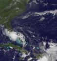
GOES-13 sees new Tropical Storm Bonnie raining on south Florida
Tropical Depression 3 strengthened into tropical storm Bonnie at 6:15pm EDT on July 22, when it was centered about 200 miles southeast of Nassau, Bahamas. At 5 a.m. EDT today, July 23, Bonnie was 155 miles southeast of Miami and the GOES-13 satellite has been providing forecasters a visible image of Bonnie continually. The visible image on July 23 at 1140 UTC (7:40 a.m.) EDT) from the Geostationary Operational Environmental Satellite called GOES-13 satellite showed Tropical Storm Bonnie's cloud-covered center south of Miami, Fla. GOES satellites are operated by NOAA. The NASA GOES Project, located in Greenbelt, Md. creates imagery and animations of GOES imagery.
Tropical storm watch is in effect for the east coast of Florida north of Deerfield Beach to Jupiter Inlet including Lake Okeechobee, and the Northern Gulf Coast from Destin, Florida to Morgan City, Louisiana. Tropical storm warnings are in effect for the Northwestern Bahamas, the Florida east coast from Deerfield Beach southward, including all of the Florida Keys, Florida Bay and along the Florida west coast northward to Englewood.
At 5 a.m. EDT, Bonnie's center was located near latitude 24.1 north and longitude 78.6 west, which is about 155 miles southeast of Miami, Fla. and about 165 miles east-southeast of Marathon, Florida. Maximum sustained winds were near 40 mph. Bonnie is moving toward the west- northwest near 18 mph and the National Hurricane Center expects it to continue moving in this direction over the next day or two. Bonnie is expected to pass near the Florida Keys and southern Florida then move over the eastern Gulf of Mexico tonight. Tropical storm watches issued for southern Mississippi and southeast Louisiana as Bonnie is forecast to move that way this weekend.
Miami is under a tropical storm warning today. This morning at 8:05 a.m. EDT, a large area of moderate to heavy rainfall was moving over Miami north to West Palm Beach. A flood watch is in effect through the afternoon of July 23 for all of South Florida. For live radar from the National Weather Service, visit: http://radar.weather.gov/radar.php?rid=AMX&product=NCR&overlay=11101111&....
The National Hurricane Center noted that tropical storm conditions will continue of parts of the northwestern Bahamas this morning and then spread over southern Florida, including the Keys. Bonnie is expected to produce total rain accumulations of 1 to 3 inches over south Florida with possible isolated maximum amounts of 5 inches. Additional rainfall amounts of 1 to 2 inches are possible over the northwestern Bahamas. Isolated tornadoes are possible over extreme southern Florida later today. For the latest updates on Bonnie, visit: www.nhc.noaa.gov.
GOES-13 will continue to provide coverage in visible images during the daytime and infrared images over night-time hours and will watch Bonnie as she moves into the Gulf of Mexico this weekend.
Source: NASA/Goddard Space Flight Center
Other sources
- Video: Bonnie Halts Spill Cleanupfrom CBSNews - ScienceSat, 24 Jul 2010, 2:21:13 UTC
- Video: Bonnie Halts Spill Cleanupfrom CBSNews - ScienceSat, 24 Jul 2010, 1:35:19 UTC
- Bonnie Takes Aim at an Oily Gulffrom NASA Jet Propulsion LaboratorySat, 24 Jul 2010, 0:28:19 UTC
- Oil spill workers evacuate as tropical storm bears downfrom PhysorgFri, 23 Jul 2010, 18:14:28 UTC
- What Will Happen to Gulf Oil if Bonnie Strikes?from Live ScienceFri, 23 Jul 2010, 17:21:40 UTC
- GOES-13 sees new Tropical Storm Bonnie raining on south Floridafrom Science BlogFri, 23 Jul 2010, 16:56:13 UTC
- Oil workers hurry as storm nearsfrom BBC News: Science & NatureFri, 23 Jul 2010, 16:42:09 UTC
- BP oil spill efforts threatened by stormfrom CBC: Technology & ScienceFri, 23 Jul 2010, 16:14:33 UTC
- GOES-13 sees new Tropical Storm Bonnie raining on south Floridafrom PhysorgFri, 23 Jul 2010, 15:56:28 UTC
- Tropical Storm Track Aligns With Oil Slickfrom NY Times ScienceFri, 23 Jul 2010, 4:28:20 UTC
- BP well to stay sealed as storm moves infrom LA Times - ScienceFri, 23 Jul 2010, 3:35:11 UTC
- BP 'frustrated' by storm delayfrom BBC News: Science & NatureThu, 22 Jul 2010, 22:35:28 UTC
- Storm danger stops BP spill workfrom BBC News: Science & NatureThu, 22 Jul 2010, 15:21:31 UTC
- Ships ready to leave BP well as storm brewsfrom CBC: Technology & ScienceThu, 22 Jul 2010, 10:21:10 UTC
- Storm threatens BP efforts to plug Gulf wellfrom PhysorgThu, 22 Jul 2010, 8:08:30 UTC
- Weather poses latest challenge to gulf oil spill responsefrom LA Times - ScienceThu, 22 Jul 2010, 4:56:28 UTC
