NASA sees Tropical Storm Julia born with strong thunderstorms and heavy rainfall
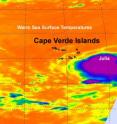
Tropical Depression 12 was born in the far eastern Atlantic Ocean yesterday, Sept. 12 and two NASA satellites saw factors that indicated she would later strengthen into Tropical Storm Julia. Infrared imagery from NASA's Aqua satellite revealed strong convection in its center that powered the storm into tropical storm status by 11 p.m. EDT. NASA's TRMM satellite indicated very heavy rainfall from that strong area of convection. The Atmospheric Infrared Sounder (AIRS) instrument that flies on NASA's Aqua satellite gives scientists and meteorologists clues about how a tropical cyclone is behaving by providing critical temperature data. When Aqua flew over Tropical Depression 12 early on Sept. 12 the concentration of strong convection (rapidly rising air that forms thunderstorms that power a tropical cyclone) were large and surrounded the depression's center. Cloud top temperatures over a large area were as cold or colder than -63 degrees Fahrenheit, and those thunderstorms were strong. The convection continued on Sept. 12 and the storm finally strengthened into Tropical Storm Julia.
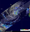
The Tropical Rainfall Measuring Mission (TRMM) satellite, which is operated jointly by NASA and the Japanese Space Agency, JAXA captured a very good daytime look at Julia when she was tropical depression 12 on September 12 at 1822 UTC (2:22p.m. EDT). TRMM showed that TD12 was starting to get organized and had moderate to very heavy rainfall converging into the center of the future storm's circulation. Julia is another in a series of 2010 tropical cyclones forming near the Cape Verde Islands off the African Coast.
Tropical Storm Julia is moving away from the southernmost Cape Verde Islands today, Sept. 13, but not before she lashes them with winds and rain. Tropical storm force winds in squalls are expected over parts of the southernmost Cape Verde Islands this morning and diminish later today. In addition, much of the Cape Verde islands can expect 2 to 4 inches of rainfall with higher totals in isolated areas.
She was "born" on Sept. 12 at around 11 a.m. EDT near 12.7 North and 21.4 West. Since then, she's moved west to 14.5 North and 25.6 West, which is about 85 miles west-southwest of the southernmost Cape Verde Islands. Her maximum sustained winds are near 40 mph, and is expected to strengthen in the next couple of days, possibly reaching hurricane status. Julia is moving west-northwest near 14 mph and had a minimum central pressure of 1004 millibars.
Julia is expected to continue moving west-northwest, then turn northwest and slow down tomorrow.
Source: NASA/Goddard Space Flight Center
Articles on the same topic
- NASA satellites help see ups and downs ahead for Depression Lisa14 years ago
- GOES-13's wide view of Atlantic's Tropical Storm Lisa and low, Pacific's Georgette14 years ago
- Huge post-tropical Hurricane Igor drenched Newfoundland, Canada14 years ago
- Hurricane watches up in Canada as the GOES-13 Satellite sees Hurricane Igor still expanding14 years ago
- NASA infrared imagery sees tropical depression 14 becomes 12th tropical storm: Lisa14 years ago
- NASA's MODIS and AIRS instruments watch Igor changing shape, warming over 3 days14 years ago
- NASA sees Tropical Storm Julia getting 'dusted'14 years ago
- NASA sees record-breaking Julia being affected by Igor14 years ago
- GOES-13 sees a weaker Hurricane Julia in the 'tropical trio'14 years ago
- NASA's 3-D look into Hurricane Igor's heavy rainfall14 years ago
- NASA satellite measures monstrous Hurricane Igor as a '10 hour drive'14 years ago
- Quick-intensifying Tropical Storm Karl landfalling in Mexico14 years ago
- Stunning NASA infrared imagery of Hurricane Igor reveals a 170 degree temperature difference14 years ago
- Igor now a Category 4 hurricane with icy cloud tops and heavy rainfall14 years ago
Other sources
- Huge post-tropical Hurricane Igor drenched Newfoundland, Canadafrom Physorg14 years ago
- Video: Hurricane Igor Pummels Bermudafrom CBSNews - Science14 years ago
- Hurricane watches up in Canada as the GOES-13 Satellite sees Hurricane Igor still expandingfrom Science Blog14 years ago
- Hurricane watches up in Canada as the GOES-13 Satellite sees Hurricane Igor still expandingfrom Physorg14 years ago
- NASA infrared imagery sees tropical depression 14 becomes 12th tropical storm: Lisafrom Physorg14 years ago
- NASA infrared imagery sees tropical depression 14 becomes 12th tropical storm: Lisafrom Science Blog14 years ago
- NASA's MODIS and AIRS instruments watch Igor changing shape, warming over 3 daysfrom Physorg14 years ago
- NASA sees Tropical Storm Julia getting 'dusted'from Physorg14 years ago
- NASA’s MODIS and AIRS instruments watch Igor changing shape, warming over 3 daysfrom Science Blog14 years ago
- NASA sees Tropical Storm Julia getting ‘dusted’from Science Blog14 years ago
- Video: Hurricane Igor Pummels Bermudafrom CBSNews - Science14 years ago
- Hurricane Igor, unchained, in NASA satellite imagesfrom Physorg14 years ago
- Video: Hurricane Igor Pummels Bermudafrom CBSNews - Science14 years ago
- Hurricane Igor, Unchained, in NASA Satellite Imagesfrom NASA Jet Propulsion Laboratory14 years ago
- NASA sees record-breaking Julia being affected by Igorfrom Science Blog14 years ago
- NASA sees record-breaking Julia being affected by Igorfrom Physorg14 years ago
- OurAmazingPlanet: NASA Takes 3-D Look at Hurricane Igorfrom Space.com14 years ago
- GOES-13 sees a weaker Hurricane Julia in the ‘tropical trio’from Science Blog14 years ago
- GOES-13 sees a weaker Hurricane Julia in the 'tropical trio'from Physorg14 years ago
- NASA’s 3-D look into Hurricane Igor’s heavy rainfallfrom Science Blog14 years ago
- NASA's 3-D look into Hurricane Igor's heavy rainfallfrom Physorg14 years ago
- NASA calls Igor 'monstrous hurricane'from MSNBC: Science14 years ago
- NASA satellite measures monstrous Hurricane Igor as a '10 hour drive'from Physorg14 years ago
- Quick-intensifying Tropical Storm Karl landfalling in Mexicofrom Science Blog14 years ago
- Quick-intensifying Tropical Storm Karl landfalling in Mexicofrom Physorg14 years ago
- NASA Calls Igor 'Monstrous Hurricane'from Live Science14 years ago
- Astronauts Savor View of Hurricane 'Igor the Terrible' and Sister Stormfrom Space.com14 years ago
- Hurricane Igor as seen from spacefrom BBC News: Science & Nature14 years ago
- Video: Tracking Hurricane Igorfrom CBSNews - Science14 years ago
- Stunning NASA infrared imagery of Hurricane Igor reveals a 170 degree temperature differencefrom Science Blog14 years ago
- Stunning NASA infrared imagery of Hurricane Igor reveals a 170 degree temperature differencefrom Physorg14 years ago
- Video: Tracking Hurricane Igorfrom CBSNews - Science14 years ago
- Video: Tracking Hurricane Igorfrom CBSNews - Science14 years ago
- Hurricane Igor Now Strongest Storm—But U.S. Spared Again?from National Geographic14 years ago
- NASA sees Tropical Storm Julia born with strong thunderstorms and heavy rainfallfrom Physorg14 years ago
- NASA sees Tropical Storm Julia born with strong thunderstorms and heavy rainfallfrom Science Blog14 years ago
- NASA sees Tropical Storm Julia born with strong thunderstorms and heavy rainfallfrom Science Blog14 years ago
- Igor now a Category 4 hurricane with icy cloud tops and heavy rainfallfrom Science Blog14 years ago
- Igor now a Category 4 hurricane with icy cloud tops and heavy rainfallfrom Physorg14 years ago
- Why Are Category 5 Hurricanes So Rare?from Live Science14 years ago
- Video: Tracking Hurricane Igorfrom CBSNews - Science14 years ago


